File:Patagonia ESA24337506.jpeg

Original file (3,280 × 4,374 pixels, file size: 1.91 MB, MIME type: image/jpeg)
Captions
Captions
Summary edit
| Description |
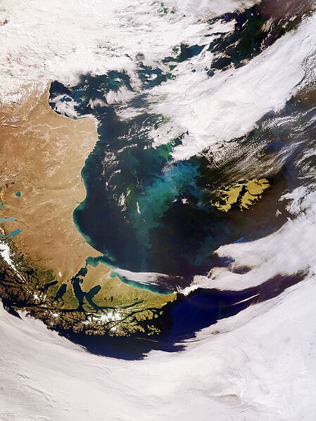
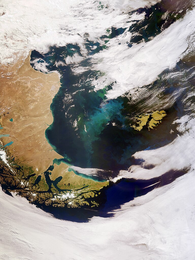
English: The Copernicus Sentinel-3 mission captured this impressive, wide-angled view of Patagonia at the southern end of South America, as well as the Falkland Islands (Malvinas). Zoom in to see this image at its full resolution or click on the circles to learn more about the features in it. Covering an area of around 673 000 sq km, Patagonia is split by Argentina and Chile. The region comprises the southern section of the Andes Mountains, with lakes, fjords, rainforests and glaciers in the west and deserts and tablelands to the east. The island archipelago of Tierra del Fuego, located at the southern tip of Patagonia (the southernmost tip of the image), is shared by Argentina and Chile, with the eastern part of the main island belonging to Argentina and the southern point of the archipelago, which forms Cape Horn, belonging to Chile. The Strait of Magellan, named after the discoverer, lies between Tierra del Fuego and mainland Argentina. Part of the Alberto de Agostini National Park can be seen in the bottom of the image. The park features a highly irregular coastline, which is deeply indented by fjords. Deemed a designated UNESCO Biosphere Reserve, the park has several tidewater glaciers and comprises the Gordon, Cook and Londonderry islands. The Falkland Islands can be seen in the far-right of the image. The islands lie in the South Atlantic Ocean, around 600 km east of Patagonia. The Falklands comprise two main islands, West Falkland and East Falkland, which are separated by the Falkland Sound – a channel that averages around 20 km in width. The swirling green and blue coloured areas are densely concentrated phytoplankton blooms. These microscopic organisms thrive in the cool, nutrient-rich waters between the coast of southern Argentina and the Falkland Islands. Nutrients carried by rivers promote phytoplankton growth, which may explain the plankton hugging the South American coastline in the image, as well as dust carried from Patagonia offshore which is then diffused on the ocean surface by strong westerly winds. In spring and summer, populations of algae in the South Atlantic often explode into enormous blooms – which float with the meandering ocean currents. Carrying a suite of cutting-edge instruments, Copernicus Sentinel-3 measures systematically Earth’s oceans, land, ice and atmosphere to monitor and understand large-scale global dynamics. Sentinel-3 measures the temperature, colour and height of the sea surface as well as the thickness of sea ice, while over land maps land, provides indices of vegetation state and measures the height of rivers and lakes. This image is also featured on the Earth from Space video programme. |
| Date | 1 July 2022 (upload date) |
| Source | Patagonia |
| Author | European Space Agency |
| Other versions |
|
| Activity | Observing the Earth |
| Mission | Sentinel-3 |
| Set | Earth observation image of the week |
| System | Copernicus |

Licensing edit

|
This image contains data from a satellite in the Copernicus Programme, such as Sentinel-1, Sentinel-2 or Sentinel-3. Attribution is required when using this image.
Attribution: Contains modified Copernicus Sentinel data 2022
The use of Copernicus Sentinel Data is regulated under EU law (Commission Delegated Regulation (EU) No 1159/2013 and Regulation (EU) No 377/2014). Relevant excerpts:
Free access shall be given to GMES dedicated data [...] made available through GMES dissemination platforms [...].
Access to GMES dedicated data [...] shall be given for the purpose of the following use in so far as it is lawful:
GMES dedicated data [...] may be used worldwide without limitations in time.
GMES dedicated data and GMES service information are provided to users without any express or implied warranty, including as regards quality and suitability for any purpose. |
This media was created by the European Space Agency (ESA).
Where expressly so stated, images or videos are covered by the Creative Commons Attribution-ShareAlike 3.0 IGO (CC BY-SA 3.0 IGO) licence, ESA being an Intergovernmental Organisation (IGO), as defined by the CC BY-SA 3.0 IGO licence. The user is allowed under the terms and conditions of the CC BY-SA 3.0 IGO license to Reproduce, Distribute and Publicly Perform the ESA images and videos released under CC BY-SA 3.0 IGO licence and the Adaptations thereof, without further explicit permission being necessary, for as long as the user complies with the conditions and restrictions set forth in the CC BY-SA 3.0 IGO licence, these including that:
See the ESA Creative Commons copyright notice for complete information, and this article for additional details.
|
 | |
This file is licensed under the Creative Commons Attribution-ShareAlike 3.0 IGO license. Attribution: ESA, CC BY-SA IGO 3.0
| ||
File history
Click on a date/time to view the file as it appeared at that time.
| Date/Time | Thumbnail | Dimensions | User | Comment | |
|---|---|---|---|---|---|
| current | 09:33, 1 July 2022 | | 3,280 × 4,374 (1.91 MB) | OptimusPrimeBot (talk | contribs) | #Spacemedia - Upload of https://www.esa.int/var/esa/storage/images/esa_multimedia/images/2022/07/patagonia/24337495-1-eng-GB/Patagonia.jpg via Commons:Spacemedia |
You cannot overwrite this file.
File usage on Commons
The following 2 pages use this file: