File:Permian ICS & Russia.svg

Size of this PNG preview of this SVG file: 448 × 600 pixels. Other resolutions: 179 × 240 pixels | 358 × 480 pixels | 574 × 768 pixels | 765 × 1,024 pixels | 1,530 × 2,048 pixels | 620 × 830 pixels.
Original file (SVG file, nominally 620 × 830 pixels, file size: 338 KB)
Captions
Captions
Add a one-line explanation of what this file represents
Summary edit
| Description |
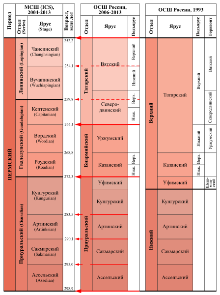
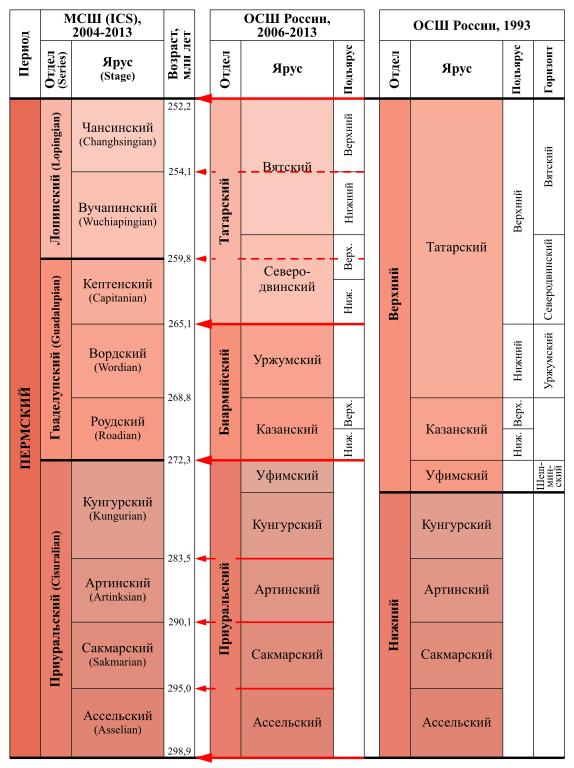
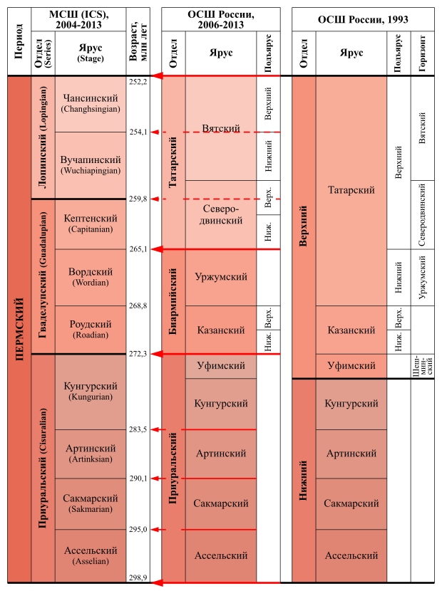
Русский: Международная стратиграфическая шкала пермской системы с 2004 года, Общая стратиграфическая шкала России на 1993 год и с 2006 года и их основные корреляционные уровни. |
| Date | |
| Source | Own work |
| Author | Alnagov |
Licensing edit
I, the copyright holder of this work, hereby publish it under the following license:
This file is licensed under the Creative Commons Attribution-Share Alike 3.0 Unported license.
- You are free:
- to share – to copy, distribute and transmit the work
- to remix – to adapt the work
- Under the following conditions:
- attribution – You must give appropriate credit, provide a link to the license, and indicate if changes were made. You may do so in any reasonable manner, but not in any way that suggests the licensor endorses you or your use.
- share alike – If you remix, transform, or build upon the material, you must distribute your contributions under the same or compatible license as the original.
File history
Click on a date/time to view the file as it appeared at that time.
| Date/Time | Thumbnail | Dimensions | User | Comment | |
|---|---|---|---|---|---|
| current | 21:43, 17 January 2014 | | 620 × 830 (338 KB) | Alnagov (talk | contribs) | Исправил ошибку в слове Подъярус |
| 21:18, 17 January 2014 |  | 620 × 830 (338 KB) | Alnagov (talk | contribs) | Международная стратиграфическая шкала пермской системы 2004 года с изменениями на 2013 г., Общая стратиграфическая шкала России на 2006-2013 гг. | |
| 19:36, 17 January 2014 |  | 620 × 830 (334 KB) | Alnagov (talk | contribs) | User created page with UploadWizard |
You cannot overwrite this file.
File usage on Commons
There are no pages that use this file.
File usage on other wikis
The following other wikis use this file:
- Usage on ru.wikipedia.org