File:Petrusbertius.jpg

No higher resolution available.
Petrusbertius.jpg (500 × 354 pixels, file size: 160 KB, MIME type: image/jpeg)
Captions
Captions
Add a one-line explanation of what this file represents
Summary edit
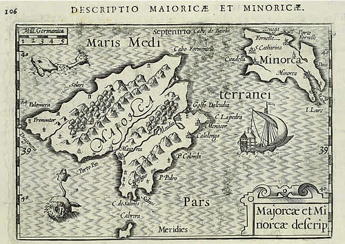
| Description |
English: Map of the Balearic Islands by Petrus Bertius.
Español: Mapa de Petrus Bertius, mostrando las Islas Baleares. |
||||||||||||||||||||
| Date | |||||||||||||||||||||
| Source | Flickreview | ||||||||||||||||||||
| Author |
|
||||||||||||||||||||

Licensing edit
|
This work is in the public domain in its country of origin and other countries and areas where the copyright term is the author's life plus 100 years or fewer. This work is in the public domain in the United States because it was published (or registered with the U.S. Copyright Office) before January 1, 1929. | |
| This file has been identified as being free of known restrictions under copyright law, including all related and neighboring rights. | |
File history
Click on a date/time to view the file as it appeared at that time.
| Date/Time | Thumbnail | Dimensions | User | Comment | |
|---|---|---|---|---|---|
| current | 12:47, 16 December 2009 | | 500 × 354 (160 KB) | CBA11 (talk | contribs) | {{Information |Description={{en|1=Map of Petrus Bertius (1602), showing the Balearic Islands}} {{es|1=Mapa de Petrus Bertius, mostrando las Islas Baleares}} |Source=http://farm1.static.flickr.com/168/395500387_dca3a7243b.jpg |Author=petrus bertius |Date= |
You cannot overwrite this file.
File usage on Commons
There are no pages that use this file.
File usage on other wikis
The following other wikis use this file:
- Usage on ca.wikipedia.org
- Usage on en.wikipedia.org
- Usage on es.wikipedia.org
- Usage on pt.wikipedia.org