File:Phosphate Mines in Jordan ast 2005258.jpg

Original file (1,832 × 3,276 pixels, file size: 2.01 MB, MIME type: image/jpeg)
Captions
Captions
| Description |
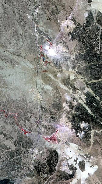
The Advanced Spaceborne Thermal Emission and Reflection Radiometer (ASTER) on NASA’s Terra satellite captured this image of a Jordanian phosphate mine. In the lower part of the image, just left of center, a network of rectangles indicates part of the mining operation. In the east are clusters of almost perfectly round shapes, some of them colored electric blue. These blue pools may hold shallow water and/or water-soaked salts. Phosphate mining often involves a floatation process in which phosphate particles float on the surface of water. A close look at the top middle part of the image shows a complex of round shapes that may have been used in earlier operations. In the left part of the image, the spray of red indicates vegetation. Although the vegetation appears bright in this image, it is probably sparse. The large off-white shape near the bottom of the image indicates a dried-up riverbed, and it follows a meandering path from the hills in the east, where the riverbed is darker in color. As it changed course, the now-dry river once sported a mesh of braided streams that left their own dry beds near the bottom of the image. The current mining operation probably takes advantage of phosphate-rich rocks residing in this riverbed. |
|||||
| Date | ||||||
| Source | Earth Observatory | |||||
| Author |
|
|||||
| Permission (Reusing this file) |
|

File history
Click on a date/time to view the file as it appeared at that time.
| Date/Time | Thumbnail | Dimensions | User | Comment | |
|---|---|---|---|---|---|
| current | 16:59, 15 June 2008 | | 1,832 × 3,276 (2.01 MB) | CarolSpears (talk | contribs) | {{Information |Description=The Advanced Spaceborne Thermal Emission and Reflection Radiometer (ASTER) on NASA’s Terra satellite captured this image of a Jordanian phosphate mine. |Source=[[http://earthobservatory.nasa.gov/Newsroom/NewImages/images.php3? |
You cannot overwrite this file.
File usage on Commons
The following page uses this file:
File usage on other wikis
The following other wikis use this file:
- Usage on el.wikipedia.org
- Usage on en.wikipedia.org
- Usage on hi.wikipedia.org
- Usage on nn.wikipedia.org
- Usage on sl.wikipedia.org
- Usage on uk.wikipedia.org