File:Piñas vial.png

Size of this preview: 800 × 553 pixels. Other resolutions: 320 × 221 pixels | 640 × 442 pixels | 1,024 × 708 pixels | 1,392 × 962 pixels.
Original file (1,392 × 962 pixels, file size: 230 KB, MIME type: image/png)
Captions
Captions
Add a one-line explanation of what this file represents
Summary edit
| Description |
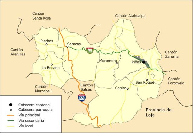
Español: Mapa de Piñas en el que se muestra las carreteras principales.
English: Piñas map which shows the main roads. |
| Date | |
| Source | |
| Author | Gobierno Autónomo Descentralizado Municipal de Piñas and edit by juanpa780874 |
| Permission (Reusing this file) |
This file is licensed under the Creative Commons Attribution 3.0 Unported license.
Español: Todo el contenido de su web se encuentra bajo licencia CC-BY-3.0
English: All content on its website is licensed under CC-BY-3.0 |
Licensing edit
This file is licensed under the Creative Commons Attribution 3.0 Unported license.
- You are free:
- to share – to copy, distribute and transmit the work
- to remix – to adapt the work
- Under the following conditions:
- attribution – You must give appropriate credit, provide a link to the license, and indicate if changes were made. You may do so in any reasonable manner, but not in any way that suggests the licensor endorses you or your use.
File history
Click on a date/time to view the file as it appeared at that time.
| Date/Time | Thumbnail | Dimensions | User | Comment | |
|---|---|---|---|---|---|
| current | 14:36, 26 July 2012 | | 1,392 × 962 (230 KB) | Juanpa780874 (talk | contribs) | Corregido errata en Cantón Santa Rosa y añadido logos de las vías principal y secundaria. |
| 14:38, 20 July 2012 |  | 1,392 × 962 (225 KB) | Juanpa780874 (talk | contribs) |
You cannot overwrite this file.
File usage on Commons
There are no pages that use this file.
File usage on other wikis
The following other wikis use this file:
- Usage on es.wikipedia.org