File:Pic Odles Stevia Daunëi Sëlva Ciandepinëi te Gherdëina da Mont de Sëura dinviern.jpg

Size of this preview: 799 × 200 pixels. Other resolutions: 320 × 80 pixels | 640 × 160 pixels | 1,024 × 256 pixels | 1,280 × 320 pixels | 2,560 × 641 pixels | 20,500 × 5,132 pixels.
Original file (20,500 × 5,132 pixels, file size: 94.73 MB, MIME type: image/jpeg)
Captions
Captions
Add a one-line explanation of what this file represents
| Warning | The original file is very high-resolution. It might not load properly or could cause your browser to freeze when opened at full size. |
|---|
Summary edit
| Description |
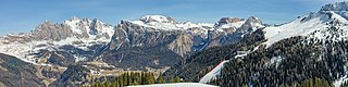
English: The Odles Group, the Ncisles mountain, the Stevia mountain, Col dala Pieres peak in the Puez-Geisler Nature Park (UNESCO World Heritage Site), the Ciandepinëi skiing area Dolomites.
Deutsch: Die Geislerspitzen, die Mastlé- und Cislesalm, Der Stevia Fels und Col dala Pieres. Naturpark Puez-Geisler das Schigebiet Ciandepinëi in den Südtiroler Dolomiten.
Italiano: Le Odle, l'alpe Cisles Col dala Pieres e l'alpe di Stevia Parco naturale Puez-Odle nelle Dolomiti |
||||||
| Date | |||||||
| Source | Own work | ||||||
| Author |
|
||||||
| Permission (Reusing this file) |
Own work, attribution required (Multi-license with GFDL and Creative Commons CC-BY 2.5). Capture: Photo by Wolfgang Moroder | ||||||
| Other versions |
 |


|
NOTE: This image is a panorama consisting of multiple frames that were merged or stitched in software. As a result, this image necessarily underwent some form of digital manipulation. These manipulations may include blending, blurring, cloning, and colour and perspective adjustments. As a result of these adjustments, the image content may be slightly different from reality at the points where multiple images were combined. This manipulation is often required due to lens, perspective, and parallax distortions.
|
| Camera location | | View this and other nearby images on: OpenStreetMap |
|---|
Licensing edit
This file is licensed under the Creative Commons Attribution-Share Alike 3.0 Unported license.
- You are free:
- to share – to copy, distribute and transmit the work
- to remix – to adapt the work
- Under the following conditions:
- attribution – You must give appropriate credit, provide a link to the license, and indicate if changes were made. You may do so in any reasonable manner, but not in any way that suggests the licensor endorses you or your use.
- share alike – If you remix, transform, or build upon the material, you must distribute your contributions under the same or compatible license as the original.
File history
Click on a date/time to view the file as it appeared at that time.
| Date/Time | Thumbnail | Dimensions | User | Comment | |
|---|---|---|---|---|---|
| current | 21:03, 4 April 2019 | 20,500 × 5,132 (94.73 MB) | Moroder (talk | contribs) | {{Largeimage}} == {{int:filedesc}} == {{Information |Description= {{en|1= The Odles Group, the Ncisles mountain, the Stevia mountain, ''Col dala Pieres'' peak in the Puez-Geisler Nature Park, Ciandepionëi {{w|Dolomites}}. A UNESCO World Heritage Site.}} {{de|1=Die Geislerspitzen, die Mastlé- und Cislesalm, Der Stevia Fels und ''Col dala Pieres''. Naturpark Puez-Geisler das Schigebiet in den Südtiroler Dolomiten.}} {{it|1=Le Odle,... |
You cannot overwrite this file.
File usage on Commons
The following 5 pages use this file:
- User:Adeletron 3030/botgalleries/Sports/2019 April 4-6
- User:Mai-Sachme/South Tyrol/2019 April 1-10
- Commons:Featured picture candidates/File:Pic Odles Stevia Daunëi Sëlva Ciandepinëi te Gherdëina da Mont de Sëura dinviern.jpg
- Commons:Featured picture candidates/Log/April 2019
- File:Pic Odles Stevia Daunëi Sëlva Ciandepinëi te Gherdëina da Mont de Sëura dinviern.jpg
File usage on other wikis
The following other wikis use this file:
- Usage on lld.wikipedia.org