File:Pieter van der Aa Canada 1713.jpg
Size of this preview: 800 × 574 pixels. Other resolutions: 320 × 229 pixels | 640 × 459 pixels | 1,032 × 740 pixels.
Original file (1,032 × 740 pixels, file size: 477 KB, MIME type: image/jpeg)
Captions
Captions
Add a one-line explanation of what this file represents
Summary edit
| Description |
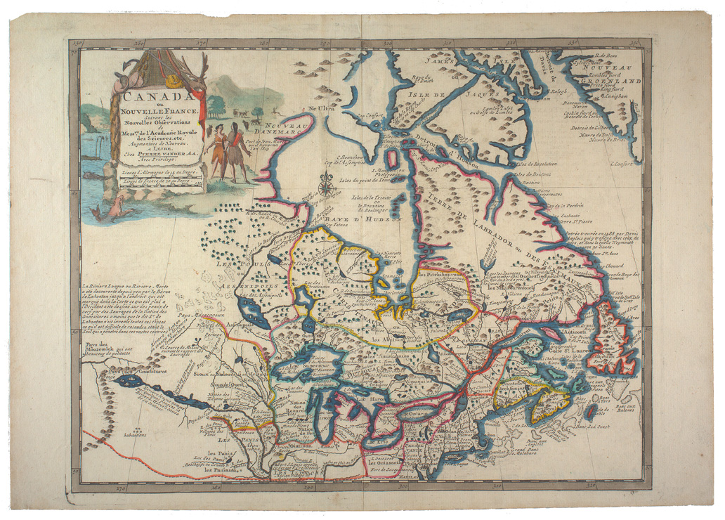
English: Historical map of Eastern Canada or Nouvelle France
Français : Canada ou Nouvelle-France suivant les nouvelles observations de Messieurs de l'Académie Royale des Sciences |
| Date | |
| Source | http://fortress.uccb.ns.ca/Search/1713Aa-1.jpg and http://fortress.uccb.ns.ca/Search/1713Aa-1.jpg |
| Author | Pieter van der Aa |
| Permission (Reusing this file) |
PD-old |
Licensing edit
|
This work is in the public domain in its country of origin and other countries and areas where the copyright term is the author's life plus 100 years or fewer. | |
| This file has been identified as being free of known restrictions under copyright law, including all related and neighboring rights. | |
File history
Click on a date/time to view the file as it appeared at that time.
| Date/Time | Thumbnail | Dimensions | User | Comment | |
|---|---|---|---|---|---|
| current | 22:28, 19 December 2006 | | 1,032 × 740 (477 KB) | JuTa (talk | contribs) | {{Information |Description=Historical map of Eastern Canada or Nouvelle France |Source=http:/http://fortress.uccb.ns.ca/Search/1713Aa-1.jpg and http://fortress.uccb.ns.ca/Search/1713Aa-1.jpg |Date=1713 |Author=Pieter van der Aa |Permission=PD-old |oth |
You cannot overwrite this file.
File usage on Commons
The following page uses this file:
File usage on other wikis
The following other wikis use this file:
- Usage on de.wikipedia.org
- Usage on fr.wikipedia.org