File:Pinus monophylla ssp californiarum range map 2.png

Size of this preview: 600 × 600 pixels. Other resolutions: 240 × 240 pixels | 480 × 480 pixels | 768 × 768 pixels | 1,024 × 1,024 pixels | 2,048 × 2,048 pixels | 11,321 × 11,321 pixels.
Original file (11,321 × 11,321 pixels, file size: 552 KB, MIME type: image/png)
Captions
Captions
Add a one-line explanation of what this file represents
Summary edit
| Description |
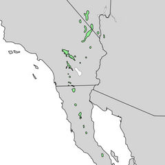
English: Pinus californiarum (syn. Pinus monophylla subsp. californiarum) range map |
| Date | |
| Source | USGS Colorado Plateau Research Station: Digitized Range Maps for Modern Plants of the Southwest |
| Author | USGS Global Change Research Program project (Past, recent, and 21st century vegetation change in the arid south-west): Kenneth L. Cole, George Ferguson, John A. Cannella, and Samantha T. Arundel. |
Licensing edit
This work is in the public domain in the United States because it is a work prepared by an officer or employee of the United States Government as part of that person’s official duties under the terms of Title 17, Chapter 1, Section 105 of the US Code.
Note: This only applies to original works of the Federal Government and not to the work of any individual U.S. state, territory, commonwealth, county, municipality, or any other subdivision. This template also does not apply to postage stamp designs published by the United States Postal Service since 1978. (See § 313.6(C)(1) of Compendium of U.S. Copyright Office Practices). It also does not apply to certain US coins; see The US Mint Terms of Use.
|
 | |
| This file has been identified as being free of known restrictions under copyright law, including all related and neighboring rights. | ||
File history
Click on a date/time to view the file as it appeared at that time.
| Date/Time | Thumbnail | Dimensions | User | Comment | |
|---|---|---|---|---|---|
| current | 16:22, 10 November 2013 | | 11,321 × 11,321 (552 KB) | Nonenmac (talk | contribs) | User created page with UploadWizard |
You cannot overwrite this file.
File usage on Commons
The following 4 pages use this file: