File:Piracy Decline LRIT.png
Size of this preview: 800 × 319 pixels. Other resolutions: 320 × 127 pixels | 640 × 255 pixels | 1,502 × 598 pixels.
Original file (1,502 × 598 pixels, file size: 1.17 MB, MIME type: image/png)
Captions
Captions
Add a one-line explanation of what this file represents
Summary edit
| Description |
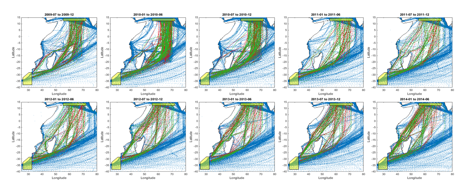
English: Time series of maritime traffic crossing the Indian Ocean showing the effect of piracy and its progressive decline in re-routing ships. Each sub-plot shows 6-month colour-coded trips, red southbound and green northbound, using Long Range Identification and Tracking (LRIT) historical data. Operational authorities requested an increase of LRIT reporting frequency from ships in 2009 and 2010 in order to better track them remotely in the High Risk Area. The increase of tracking points can be erroneously perceived as an apparently higher volume of traffic with respect to other periods.
Published in Vespe M., Greidanus H., Alvarez M., 'The declining impact of piracy on maritime transport in the Indian Ocean: Statistical analysis of 5-year vessel tracking data'. Marine Policy. 59: 9–15. DOI:10.1016/j.marpol.2015.04.018. [1] |
| Date | |
| Source | Own work |
| Author | Lampred8 |
Licensing edit
I, the copyright holder of this work, hereby publish it under the following license:
This file is licensed under the Creative Commons Attribution-Share Alike 4.0 International license.
- You are free:
- to share – to copy, distribute and transmit the work
- to remix – to adapt the work
- Under the following conditions:
- attribution – You must give appropriate credit, provide a link to the license, and indicate if changes were made. You may do so in any reasonable manner, but not in any way that suggests the licensor endorses you or your use.
- share alike – If you remix, transform, or build upon the material, you must distribute your contributions under the same or compatible license as the original.
- ↑ (1 September 2015). "The declining impact of piracy on maritime transport in the Indian Ocean: Statistical analysis of 5-year vessel tracking data". Marine Policy 59: 9–15. DOI:10.1016/j.marpol.2015.04.018.
File history
Click on a date/time to view the file as it appeared at that time.
| Date/Time | Thumbnail | Dimensions | User | Comment | |
|---|---|---|---|---|---|
| current | 16:35, 31 July 2016 | 1,502 × 598 (1.17 MB) | Lampred8 (talk | contribs) | Cross-wiki upload from en.wikipedia.org |
You cannot overwrite this file.
File usage on Commons
There are no pages that use this file.
File usage on other wikis
The following other wikis use this file:
- Usage on en.wikipedia.org