File:Plaats waar Anthoni van Leeuwenhoek in 1674 het water verzamelde dat leidde tot de ontdekking van micro-organismen.png

Size of this preview: 800 × 439 pixels. Other resolutions: 320 × 176 pixels | 640 × 351 pixels | 1,024 × 562 pixels | 1,697 × 932 pixels.
Original file (1,697 × 932 pixels, file size: 2.49 MB, MIME type: image/png)
Captions
Captions
Add a one-line explanation of what this file represents
Summary edit
| Description |
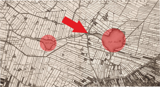
Nederlands: De pijl wijst naar de plaats, halverwege het Berkelse Westmeer en het Oostmeer, waar een tolhek was geplaatst en vanwaar het water in de vaart die beide meren met elkaar verbond vanaf de weg eenvoudig kon worden bereikt. |
| Date | |
| Source | http://imagebase.ubvu.vu.nl/cdm/ref/collection/krt/id/1354 |
| Author | Nicolaas (Klaas) Kruik (1678-1754), aka Nicolaes Krukius / Nicolaus Samuelis Cruquius |
| Camera location | | View this and other nearby images on: OpenStreetMap |
|---|
Om de exacte coördinaten te kunnen bepalen is de kaart, die is vervaardigd in 1712, over een Google Maps kaart gelegd.
Licensing edit
|
This work is in the public domain in its country of origin and other countries and areas where the copyright term is the author's life plus 70 years or fewer. This work is in the public domain in the United States because it was published (or registered with the U.S. Copyright Office) before January 1, 1929. | |
| This file has been identified as being free of known restrictions under copyright law, including all related and neighboring rights. | |
File history
Click on a date/time to view the file as it appeared at that time.
| Date/Time | Thumbnail | Dimensions | User | Comment | |
|---|---|---|---|---|---|
| current | 20:44, 2 May 2017 | | 1,697 × 932 (2.49 MB) | Zeddammer (talk | contribs) | User created page with UploadWizard |
You cannot overwrite this file.
File usage on Commons
There are no pages that use this file.
File usage on other wikis
The following other wikis use this file:
- Usage on nl.wikipedia.org