File:Plan de Roussel 1731 - extrait Boulogne et Billancourt.jpg

Size of this preview: 695 × 600 pixels. Other resolutions: 278 × 240 pixels | 556 × 480 pixels | 890 × 768 pixels | 1,186 × 1,024 pixels | 1,587 × 1,370 pixels.
Original file (1,587 × 1,370 pixels, file size: 1.17 MB, MIME type: image/jpeg)
Captions
Captions
Add a one-line explanation of what this file represents
Summary edit
| Description |
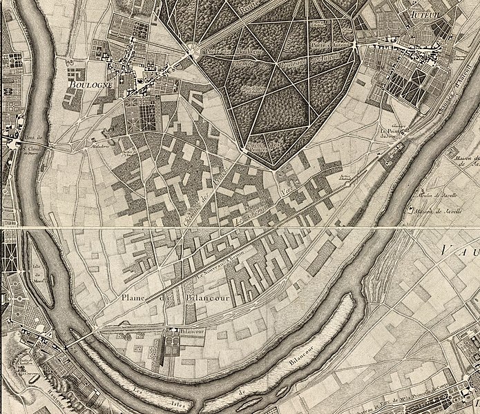
Français : Paris, ses fauxbourgs et ses environs : où se trouve le détail des villages, châteaux, grands chemins pavez, et autres, des hauteurs, bois, vignes, terres, et prez, levez géometriquement. Extrait limité à Boulogne et Billancourt |
||
| Date | |||
| Source |
|
||
| Author | Roussel | ||
| Other versions | Roussel, Paris, ses fauxbourgs et ses environs, 1731.jpg |

Licensing edit
|
This work is in the public domain in its country of origin and other countries and areas where the copyright term is the author's life plus 100 years or fewer. | |
| This file has been identified as being free of known restrictions under copyright law, including all related and neighboring rights. | |
File history
Click on a date/time to view the file as it appeared at that time.
| Date/Time | Thumbnail | Dimensions | User | Comment | |
|---|---|---|---|---|---|
| current | 19:45, 15 December 2018 | | 1,587 × 1,370 (1.17 MB) | Prokofiev (talk | contribs) | User created page with UploadWizard |
You cannot overwrite this file.
File usage on Commons
There are no pages that use this file.
File usage on other wikis
The following other wikis use this file:
- Usage on fr.wikipedia.org