File:Plan goroda Odessy LOC 2014592004.tif

Size of this JPG preview of this TIF file: 800 × 511 pixels. Other resolutions: 320 × 204 pixels | 640 × 409 pixels | 1,024 × 654 pixels | 1,280 × 818 pixels | 2,560 × 1,636 pixels | 12,079 × 7,718 pixels.
Original file (12,079 × 7,718 pixels, file size: 266.72 MB, MIME type: image/tiff)
Captions
Captions
Add a one-line explanation of what this file represents
Summary
edit| Warning | The original file is very high-resolution. It might not load properly or could cause your browser to freeze when opened at full size. |
|---|
| Description |
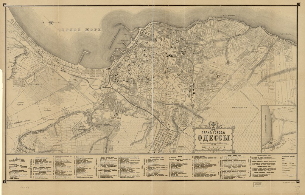
English: City street map showing principal buildings, police-district numbers, block numbers, some lot/tract lines, and names of landowners of larger tracts. Relief shown by hachures and rock drawings. In Russian (old spelling). Oriented with north to the left. LC copy imperfect: Laminated, fold-lined (before lamination), darkened, mounted on cloth backing, halved to enable folding (after lamination), possibly removed from textual publication. Includes index to points-of-interest (by district), local-area inset, and coat-of-arms. Available also through the Library of Congress Web site as a raster image. |
||
| Title | Plan goroda Odessy | ||
| Shelf ID | G7104.O3 1894 .D5 | ||
| Date | |||
| Source | https://www.loc.gov/item/2014592004/ | ||
| Author | Diterikhs, M. M.; Odesa (Ukraine) | ||
| Permission (Reusing this file) |
|
||
| Other versions |
|
||
| Location | Ukraine · Odesa | ||
| Part of | American Memory · Cities And Towns · Catalog · Geography And Map Division | ||
| Subject | Ukraine · Cadastral Maps · Landowners · Maps · Real Property · Odesa (Ukraine) · Odesa |


Licensing
edit|
This is a faithful photographic reproduction of a two-dimensional, public domain work of art. The work of art itself is in the public domain for the following reason:
The official position taken by the Wikimedia Foundation is that "faithful reproductions of two-dimensional public domain works of art are public domain".
This photographic reproduction is therefore also considered to be in the public domain in the United States. In other jurisdictions, re-use of this content may be restricted; see Reuse of PD-Art photographs for details. | ||||
File history
Click on a date/time to view the file as it appeared at that time.
| Date/Time | Thumbnail | Dimensions | User | Comment | |
|---|---|---|---|---|---|
| current | 03:49, 3 June 2018 |  | 12,079 × 7,718 (266.72 MB) | Fæ (talk | contribs) | LOC Maps https://www.loc.gov/item/2014592004/ #3038 |
You cannot overwrite this file.
File usage on Commons
The following page uses this file: