File:Plano da Rede 1930 - Gazeta CF 1167 1936.jpg
Size of this preview: 323 × 598 pixels. Other resolutions: 129 × 240 pixels | 399 × 739 pixels.
Original file (399 × 739 pixels, file size: 232 KB, MIME type: image/jpeg)
Captions
Captions
Add a one-line explanation of what this file represents
Summary edit
| Description |
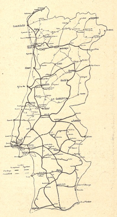
Português: Mapa com a rede ferroviária construída em Portugal, e dos projectos introduzidos pelo Plano Geral da Rede Ferroviária, publicado pelo Decreto n.º 18:190, de 28 de Março de 1930.
Esta imagem foi publicada na Gazeta dos Caminhos de Ferro n.º 1167, de 1 de Agosto de 1936, e digitalizada pela Hemeroteca Municipal de Lisboa.
English: Map with the railway network in Portugal, and the projects introduced by the Plano Geral da Rede Ferroviária (General Plan of the Railway Network), published by the Decree No. 18:190, of the 28th March 1930.
This image was published on the Gazeta dos Caminhos de Ferro magazine no. 1167, of the 1st August 1936, and scanned by the Hemeroteca Municipal de Lisboa. |
| Date | between 1930 and 1936 |
| Source | http://hemerotecadigital.cm-lisboa.pt/OBRAS/GazetaCF/1936/N1167/N1167_item1/P4.html |
| Author | Unknown author |
| Other versions |
.jpg)
.jpg)
Licensing edit
This image (or other media file) is in the public domain because its copyright has expired and its author is anonymous.
This applies to the European Union and those countries with a copyright term of 70 years after the work was made available to the public and the author never disclosed their identity. Important: Always mention where the image comes from, as far as possible, and make sure the author never claimed authorship. |
 | |
 |
Note: In Germany and possibly other countries, certain anonymous works published before July 1, 1995 are copyrighted until 70 years after the death of the author. See Übergangsrecht. Please use this template only if the author never claimed authorship or their authorship never became public in any other way. If the work is anonymous or pseudonymous (e.g., published only under a corporate or organization's name), use this template for images published more than 70 years ago.
For a work made available to the public in the United Kingdom, please use Template:PD-UK-unknown instead.
|
File history
Click on a date/time to view the file as it appeared at that time.
| Date/Time | Thumbnail | Dimensions | User | Comment | |
|---|---|---|---|---|---|
| current | 11:31, 28 January 2016 | | 399 × 739 (232 KB) | Ajpvalente (talk | contribs) | User created page with UploadWizard |
You cannot overwrite this file.
File usage on Commons
The following 7 pages use this file:
- User:Chumwa/OgreBot/Potential transport maps/2016 January 21-31
- User:Chumwa/OgreBot/Public transport information/2016 January 21-31
- User:Chumwa/OgreBot/Transport Maps/2016 January 21-31
- User:Chumwa/OgreBot/Travel and communication maps/2016 January 21-31
- User:Jcornelius/Portugal Public Transport/2016 January 21-31
- File:Plano da Rede 1930 (Bxº Alentejo & Algarve).jpg
- File:RedeFerr.1930(LBA+proj).jpg
File usage on other wikis
The following other wikis use this file:
- Usage on en.wikipedia.org
- Usage on pt.wikipedia.org
- Linha da Beira Alta
- Ramal da Lousã
- Estação Ferroviária da Guarda
- Ramal de Tomar
- Linha do Oeste
- Estação Ferroviária do Entroncamento
- Linha do Dão
- Estação Ferroviária do Setil
- Ramal de Rio Maior
- Linha de Lamego
- Linha do Vale do Lima
- Estação Ferroviária de Caldas da Rainha
- Estação Ferroviária de Santa Comba Dão
- Estação Ferroviária de Leiria
- Estação Ferroviária de Mogadouro
- Estação Ferroviária de Santiago do Cacém
- Estação Ferroviária de Macedo de Cavaleiros
- Linha da Ericeira
- Linha do Cávado
- Transversal de Chacim
- Linha de Braga a Guimarães
- Transversal de Beja
- Linha do Côa
- Linha de Alverca