File:Plano geométrico del Río Guayaquil desde el surgidero de la punta hasta la ciudad LOC 90682836.tif

Size of this JPG preview of this TIF file: 800 × 303 pixels. Other resolutions: 320 × 121 pixels | 640 × 242 pixels | 1,024 × 388 pixels | 1,280 × 485 pixels | 2,560 × 970 pixels | 11,922 × 4,515 pixels.
Original file (11,922 × 4,515 pixels, file size: 154 MB, MIME type: image/tiff)
Captions
Captions
Add a one-line explanation of what this file represents
Summary edit
| Description |
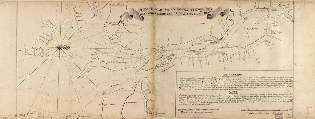
English: Shows Guayas River. Depths shown by soundings. Oriented with north to the right. Watermarks: IV; and, Strasburg fleur-de-lis. Pen-and-ink. Mounted on cloth backing. LC Luso-Hispanic World, 411 Available also through the Library of Congress Web site as a raster image. Includes index and note. Maggs number annotated in pencil in lower right corner: 117. Vault |
||
| Title | Plano geométrico del Río Guayaquil desde el surgidero de la punta hasta la ciudad | ||
| Shelf ID | G5302.G9 178- .P5 | ||
| Date | |||
| Source | https://www.loc.gov/item/90682836/ | ||
| Author | Unknown author | ||
| Permission (Reusing this file) |
|
||
| Other versions |
|
||
| Location | Guayas River · Ecuador | ||
| Part of | American Memory · Catalog · Geography And Map Division · Cultural Landscapes | ||
| Subject | Maps, Manuscript · Guayas River · Early Works To 1800 · Manuscript Maps · Guayas River (Ecuador) · Ecuador |

Licensing edit
|
This is a faithful photographic reproduction of a two-dimensional, public domain work of art. The work of art itself is in the public domain for the following reason:
The official position taken by the Wikimedia Foundation is that "faithful reproductions of two-dimensional public domain works of art are public domain".
This photographic reproduction is therefore also considered to be in the public domain in the United States. In other jurisdictions, re-use of this content may be restricted; see Reuse of PD-Art photographs for details. | ||||
File history
Click on a date/time to view the file as it appeared at that time.
| Date/Time | Thumbnail | Dimensions | User | Comment | |
|---|---|---|---|---|---|
| current | 13:33, 9 June 2018 | 11,922 × 4,515 (154 MB) | Fæ (talk | contribs) | LOC Maps https://www.loc.gov/item/90682836/ #24792 |
You cannot overwrite this file.
File usage on Commons
The following page uses this file: