File:Poland administrative divisions comparison map (1999 and pre-1999).svg

Size of this PNG preview of this SVG file: 643 × 600 pixels. Other resolutions: 257 × 240 pixels | 515 × 480 pixels | 823 × 768 pixels | 1,098 × 1,024 pixels | 2,195 × 2,048 pixels | 1,000 × 933 pixels.
Original file (SVG file, nominally 1,000 × 933 pixels, file size: 2.26 MB)
Captions
Captions
Add a one-line explanation of what this file represents
Summary edit
.svg&action=edit§ion=1)
| Description |
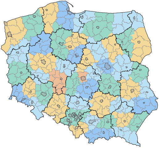
English: Map of Polish voivodeships and counties after the reform of 1 January 1999, in comparison to the voivodeships borders until 31 December 1998.
Legend: black lines – new voivodeship borders, gray lines – new county borders (cities with county rights emphasised), coloured areas – old voivodeship borders. Polski: Mapa województw i powiatów po reformie z 1 stycznia 1999 roku, w porównaniu z granicami województw obowiązującymi do 31 grudnia 1998 roku. Legenda: czarne linie – nowe granice województw, szare linie – nowe granice powiatów (z wyróżnionymi miastami na prawach powiatu), kolorowe obszary – województwa w starych granicach. |
| Date | |
| Source |
Rozporządzenie Rady Ministrów z dnia 15 października 1996 r. w sprawie określenia miast oraz gmin wchodzących w skład województw. Rozporządzenie Rady Ministrów z dnia 7 sierpnia 1998 r. w sprawie utworzenia powiatów. |
| Author | TexLacerta |
Licensing edit
.svg&action=edit§ion=2)
I, the copyright holder of this work, hereby publish it under the following license:
This file is licensed under the Creative Commons Attribution 4.0 International license.
- You are free:
- to share – to copy, distribute and transmit the work
- to remix – to adapt the work
- Under the following conditions:
- attribution – You must give appropriate credit, provide a link to the license, and indicate if changes were made. You may do so in any reasonable manner, but not in any way that suggests the licensor endorses you or your use.
File history
Click on a date/time to view the file as it appeared at that time.
| Date/Time | Thumbnail | Dimensions | User | Comment | |
|---|---|---|---|---|---|
| current | 16:43, 18 October 2023 | | 1,000 × 933 (2.26 MB) | TexLacerta (talk | contribs) | smaller margin |
| 10:08, 15 October 2023 |  | 1,000 × 933 (2.16 MB) | TexLacerta (talk | contribs) | {{Information |description={{en|1=Map of Polish voivodeships and counties after the reform of 1 January 1999, in comparison to the voivodeships borders until 31 December 1998.<br/>Legend: black lines – new voivodeship borders, gray lines – new county borders (cities with county rights emphasised), coloured areas – old voivodeship borders.}} {{pl|1=Mapa województw i powiatów po reformie z 1 stycznia 1999 roku, w porównaniu z granicami województw obowiązującymi do 31 grudnia 1998 roku.<br/>Lege... |
You cannot overwrite this file.
File usage on Commons
There are no pages that use this file.
File usage on other wikis
The following other wikis use this file:
- Usage on pl.wikipedia.org
.svg&oldid=864404785)