File:Pont-Rouge12a.jpg

Size of this preview: 698 × 599 pixels. Other resolutions: 280 × 240 pixels | 559 × 480 pixels | 894 × 768 pixels | 1,098 × 943 pixels.
Original file (1,098 × 943 pixels, file size: 324 KB, MIME type: image/jpeg)
Captions
Captions
Add a one-line explanation of what this file represents
Summary
edit
| Description |
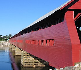
Français : Extérieur du Pont Marchand de Fort-Coulonge, Québec, Canada |
| Date | |
| Source | Own work |
| Author | Jljmt |
This photo is of a cultural heritage site in Canada, number 4463
|
| Object location | | View this and other nearby images on: OpenStreetMap |
|---|
Licensing
edit
| I, the copyright holder of this work, release this work into the public domain. This applies worldwide. In some countries this may not be legally possible; if so: I grant anyone the right to use this work for any purpose, without any conditions, unless such conditions are required by law. |
File history
Click on a date/time to view the file as it appeared at that time.
| Date/Time | Thumbnail | Dimensions | User | Comment | |
|---|---|---|---|---|---|
| current | 23:43, 6 April 2011 | | 1,098 × 943 (324 KB) | Gilbertus (talk | contribs) | cadrage et redressement |
| 20:06, 20 January 2009 |  | 1,296 × 972 (233 KB) | Kilom691 (talk | contribs) | better resolution | |
| 01:46, 14 November 2006 |  | 227 × 170 (17 KB) | Jljmt (talk | contribs) | Pont Marchand de Fort-Coulonge | |
| 01:06, 5 November 2006 |  | 454 × 340 (40 KB) | Jljmt (talk | contribs) | Extérieur du Pont Marchand de Fort-Coulonge, Québec |
You cannot overwrite this file.
File usage on Commons
The following page uses this file:
File usage on other wikis
The following other wikis use this file:
- Usage on es.wikipedia.org
- Usage on fr.wikipedia.org
- Usage on fr.wikibooks.org