File:Port Phillip 10,000.PNG
No higher resolution available.
Port_Phillip_10,000.PNG (514 × 523 pixels, file size: 20 KB, MIME type: image/png)
Captions
Captions
Add a one-line explanation of what this file represents

|
This file was moved to Wikimedia Commons from en.wikipedia using a bot script. All source information is still present. It requires review. Additionally, there may be errors in any or all of the information fields; information on this file should not be considered reliable and the file should not be used until it has been reviewed and any needed corrections have been made. Once the review has been completed, this template should be removed. For details about this file, see below. Check now! |
Summary edit
| Description |
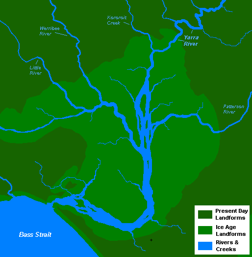
English: A very basic map of the port phillip plains approximately 10-12 thousand years ago, prior to sea level rise that filled the area of land now known as Port Phillip, and the course of the Yarra River as it emptied into Bass Strait. More exact details regarding the course of the Yarra River in the port phillip plains are needed. |
| Date | 13 November 2008 (original upload date) |
| Source | Own work |
| Author | Nick carson at English Wikipedia |
Licensing edit
| This work has been released into the public domain by its author, Nick carson at English Wikipedia. This applies worldwide. In some countries this may not be legally possible; if so: Nick carson grants anyone the right to use this work for any purpose, without any conditions, unless such conditions are required by law. |
Original upload log edit
The original description page was here. All following user names refer to en.wikipedia.
- 2008-11-13 14:20 Nick carson 514×523 (20321 bytes) A very basic map of the port phillip plains approximately 10-12 thousand years ago, prior to sea level rise that filled the area of land now known as Port Phillip, and the course of the Yarra River as it emptied into Bass Strait. More exact details regard
File history
Click on a date/time to view the file as it appeared at that time.
| Date/Time | Thumbnail | Dimensions | User | Comment | |
|---|---|---|---|---|---|
| current | 19:12, 7 January 2012 | | 514 × 523 (20 KB) | BotMultichillT (talk | contribs) | {{BotMoveToCommons|en.wikipedia|year={{subst:CURRENTYEAR}}|month={{subst:CURRENTMONTHNAME}}|day={{subst:CURRENTDAY}}}} == {{int:filedesc}} == {{Information |description={{en|1=A very basic map of the port phillip plains approximately 10-12 thousand years |
You cannot overwrite this file.
File usage on Commons
The following page uses this file:
File usage on other wikis
The following other wikis use this file:
- Usage on af.wikipedia.org
- Usage on en.wikipedia.org
- Usage on sr.wikipedia.org
- Usage on zh.wikipedia.org