File:Postleitzahlen Deutschland 4stellig bis 1993.png
Size of this preview: 476 × 599 pixels. Other resolutions: 190 × 240 pixels | 381 × 480 pixels | 610 × 768 pixels | 813 × 1,024 pixels | 1,588 × 2,000 pixels.
Original file (1,588 × 2,000 pixels, file size: 852 KB, MIME type: image/png)
Captions
Captions
Add a one-line explanation of what this file represents
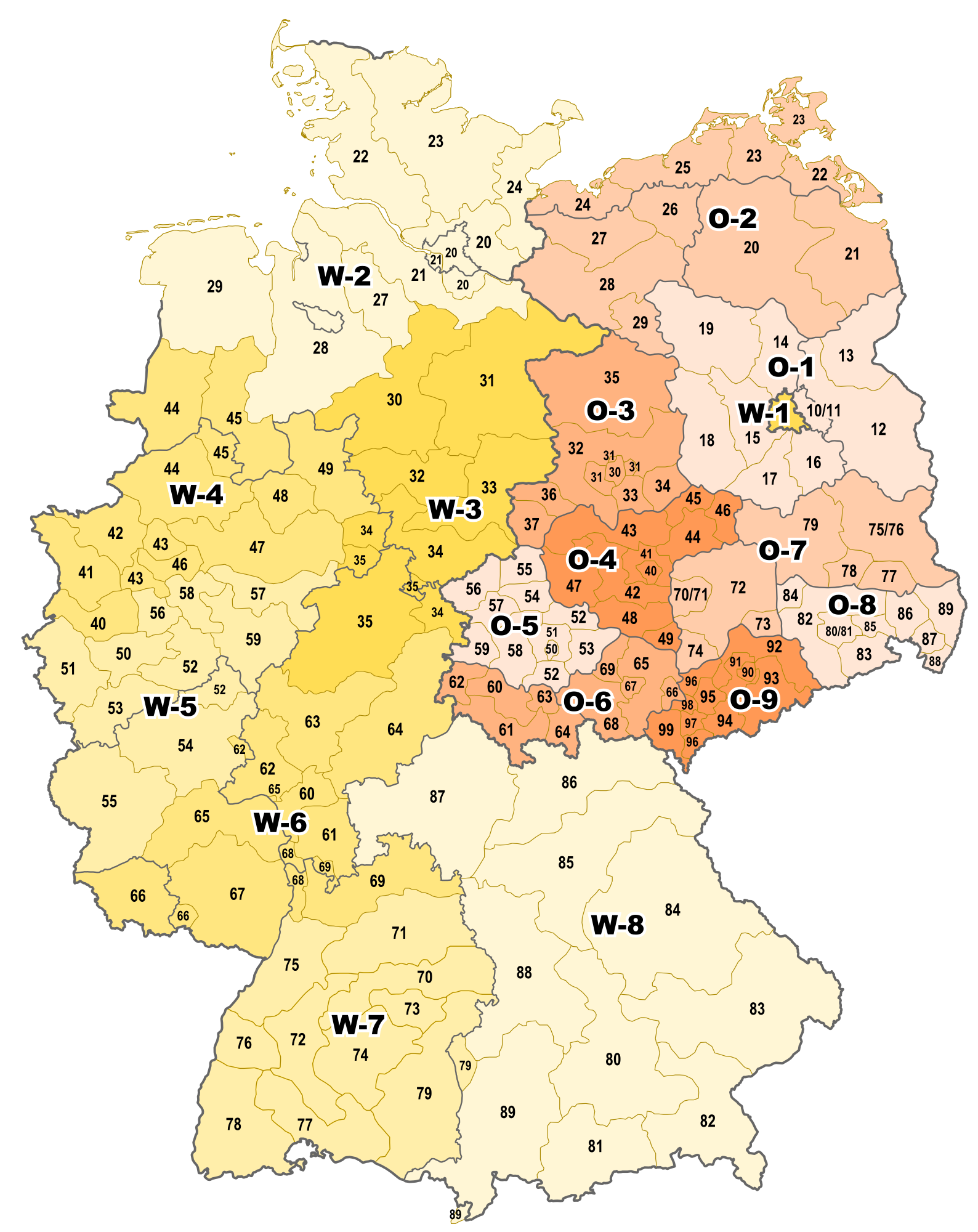
| Description | Karte des 4-stelligen PLZ-Systems in Deutschland (gültig bis 1993), eingeführt 1962 (BRD), bzw. in der DDR (1965), hier dargestellt mit den Grenzen der Bundesländer (BRD) und der Bezirke (DDR) |
| Date | |
| Source |
"own work", used:
|
| Author | Lencer |

|
This map has been made or improved in the German Kartenwerkstatt (Map Lab). You can propose maps to improve as well.
|
Licensing edit
This file is licensed under the Creative Commons Attribution-Share Alike 3.0 Unported license.
- You are free:
- to share – to copy, distribute and transmit the work
- to remix – to adapt the work
- Under the following conditions:
- attribution – You must give appropriate credit, provide a link to the license, and indicate if changes were made. You may do so in any reasonable manner, but not in any way that suggests the licensor endorses you or your use.
- share alike – If you remix, transform, or build upon the material, you must distribute your contributions under the same or compatible license as the original.

|
This map image could be re-created using vector graphics as an SVG file. This has several advantages; see Commons:Media for cleanup for more information. If an SVG form of this image is available, please upload it and afterwards replace this template with
{{vector version available|new image name}}.
It is recommended to name the SVG file “Postleitzahlen Deutschland 4stellig bis 1993.svg”—then the template Vector version available (or Vva) does not need the new image name parameter. |
File history
Click on a date/time to view the file as it appeared at that time.
| Date/Time | Thumbnail | Dimensions | User | Comment | |
|---|---|---|---|---|---|
| current | 05:06, 26 August 2010 | | 1,588 × 2,000 (852 KB) | Lencer (talk | contribs) | falsche Ebeneneinblendung gefixt |
| 10:22, 7 April 2010 |  | 1,588 × 2,000 (872 KB) | Lencer (talk | contribs) | fix 60 | |
| 12:48, 24 March 2010 |  | 1,588 × 2,000 (850 KB) | Lencer (talk | contribs) | farbänderung | |
| 06:59, 8 March 2010 |  | 1,588 × 2,000 (850 KB) | Lencer (talk | contribs) | {{Information |Description= Karte des 4-stelligen PLZ-Systems in Deutschland (gültig bis 1993), eingeführt 1962 (BRD), bzw. in der DDR (1965), hier dargestellt mit den Grenzen der Bundesländer (BRD) und der Bezirke (DDR) |Source="own work", used: :* Ü |
You cannot overwrite this file.
File usage on Commons
There are no pages that use this file.
File usage on other wikis
The following other wikis use this file:
- Usage on als.wikipedia.org
- Usage on de.wikipedia.org