File:Powiat kaliski location map.png

Size of this preview: 402 × 599 pixels. Other resolutions: 161 × 240 pixels | 322 × 480 pixels | 833 × 1,242 pixels.
Original file (833 × 1,242 pixels, file size: 228 KB, MIME type: image/png)
Captions
Captions
Add a one-line explanation of what this file represents
| Description |
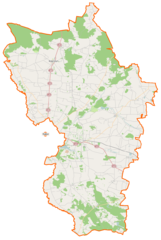
Polski: Mapa powiatu kaliskiego, Polska
English: Map of Powiat kaliski, Poland |
|||||||||
| Date | ||||||||||
| Source | You may find a page on the OpenStreetMap wiki page for Powiat kaliski | |||||||||
| Creator |
OpenStreetMap contributors OpenStreetMap contributors |
|||||||||
| Permission (Reusing this file) |
OpenStreetMap data is available under the Open Database License (details). Map tiles are licensed under the Creative Commons Attribution-ShareAlike 2.0 license (CC-BY-SA 2.0).
This file is licensed under the Creative Commons Attribution-Share Alike 2.0 Generic license.
|
|||||||||
| Geotemporal data | ||||||||||
| Bounding box |
|
|||||||||
| Georeferencing | If inappropriate please set warp_status = skip to hide. | |||||||||
File history
Click on a date/time to view the file as it appeared at that time.
| Date/Time | Thumbnail | Dimensions | User | Comment | |
|---|---|---|---|---|---|
| current | 06:06, 3 December 2014 | | 833 × 1,242 (228 KB) | VanWiel (talk | contribs) | {{OpenStreetMap | name = Powiat kaliski | location = Powiat kaliski | description = {{pl|Mapa powiatu kaliskiego, Polska}} {{en|Map of Powiat kaliski, Poland}} | top = 52.0512 | bottom = 51.5241 | l... |
You cannot overwrite this file.
File usage on Commons
There are no pages that use this file.
File usage on other wikis
The following other wikis use this file:
- Usage on eo.wikipedia.org
- Usage on pl.wikipedia.org
- Opatówek
- Powiat kaliski
- Szałe
- Joanka (powiat kaliski)
- Stawiszyn
- Bałdoń
- Beznatka
- Blizanów
- Blizanówek
- Budy Liskowskie
- Ceków
- Ceków-Kolonia
- Cienia Druga
- Cienia-Folwark
- Cienia Pierwsza
- Cienia Trzecia
- Ciepielew
- Cieszyków
- Czempisz
- Chodybki
- Danowiec
- Dzierzbin
- Dębe-Kolonia
- Dębniałki Kaliskie
- Długa Wieś Druga
- Długa Wieś Pierwsza
- Długa Wieś Trzecia
- Dębniałki (gmina Blizanów)
- Fajum (Polska)
- Gadów
- Gać Kaliska
- Godziątków
- Godziesze Małe
- Godziesze Wielkie
- Godzieszki
- Gostynie
- Iwanowice (powiat kaliski)
- Jagodziniec
- Jamnice
- Janków Drugi
- Jarantów
- Jarantów-Kolonia
- Krowica Pusta
- Krowica Zawodnia
- Kuczewola
- Kurza
- Kuszyn
- Kakawa-Kolonia
- Końska Wieś
View more global usage of this file.