File:Prachatice SK 1837 (6076-1-004).jpg

Size of this preview: 600 × 600 pixels. Other resolutions: 240 × 240 pixels | 480 × 480 pixels | 768 × 768 pixels | 1,024 × 1,024 pixels | 2,400 × 2,400 pixels.
Original file (2,400 × 2,400 pixels, file size: 2.25 MB, MIME type: image/jpeg)
Captions
Captions
Add a one-line explanation of what this file represents
Summary edit
.jpg&action=edit§ion=1)
| Description |
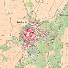
Čeština: Prachatice na císařském otisku mapy Stabilního katastru. Mapový list 6076-1-004, vydáno 1837. |
| Date | |
| Source | https://archivnimapy.cuzk.cz/uazk/coc/coc_data/6076-1/6076-1-004_index.html |
| Author | Offices of the Austrian Empire |
| Camera location | | View this and other nearby images on: OpenStreetMap |
|---|
.jpg¶ms=049.013013_N_0013.997533_E_globe:Earth_type:camera__&language=en)

|
This file was created on the basis of data provided by the Central Archives of Surveying and Land Register (State Administration of Land Surveying and Cadastre).
|

|
This file was obtained as part of the Editaton Prachatice 2 project.
|
| This file was created as a part an event supported by a Community minigrant of Wikimedia Czech Republic. Ticket: 1856. |
Licensing edit
.jpg&action=edit§ion=2)
|
This work is in the public domain in its country of origin and other countries and areas where the copyright term is the author's life plus 70 years or fewer. This work is in the public domain in the United States because it was published (or registered with the U.S. Copyright Office) before January 1, 1929. | |
| This file has been identified as being free of known restrictions under copyright law, including all related and neighboring rights. | |
File history
Click on a date/time to view the file as it appeared at that time.
| Date/Time | Thumbnail | Dimensions | User | Comment | |
|---|---|---|---|---|---|
| current | 21:02, 30 October 2019 | | 2,400 × 2,400 (2.25 MB) | Gampe (talk | contribs) | User created page with UploadWizard |
You cannot overwrite this file.
File usage on Commons
The following 2 pages use this file:
.jpg&oldid=443898184)