File:PrairiePotholeRegionMap.gif
No higher resolution available.
PrairiePotholeRegionMap.gif (295 × 302 pixels, file size: 5 KB, MIME type: image/gif)
Captions
Captions
Add a one-line explanation of what this file represents
Summary edit

|
This map image could be re-created using vector graphics as an SVG file. This has several advantages; see Commons:Media for cleanup for more information. If an SVG form of this image is available, please upload it and afterwards replace this template with
{{vector version available|new image name}}.
It is recommended to name the SVG file “PrairiePotholeRegionMap.svg”—then the template Vector version available (or Vva) does not need the new image name parameter. |
| Description |
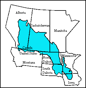
English: Map of the Prairie Pothole Region of North America. From the US Geological Survey, http://www.npwrc.usgs.gov/resource/wetlands/pothole/prairie.htm |
| Source | |
| Author |
Licensing edit
This image is in the public domain in the United States because it only contains materials that originally came from the United States Geological Survey, an agency of the United States Department of the Interior. For more information, see the official USGS copyright policy.
|
Original upload log edit
The original description page was here. All following user names refer to en.wikipedia.
- 2007-10-15 17:21 Orlady 295×302×8 (4921 bytes) Map of the Prairie Pothole Region of North America. From the US Geological Survey, http://www.npwrc.usgs.gov/resource/wetlands/pothole/prairie.htm
File history
Click on a date/time to view the file as it appeared at that time.
| Date/Time | Thumbnail | Dimensions | User | Comment | |
|---|---|---|---|---|---|
| current | 01:53, 6 April 2008 | | 295 × 302 (5 KB) | File Upload Bot (Magnus Manske) (talk | contribs) | {{BotMoveToCommons|en.wikipedia}} {{Information |Description={{en|Map of the Prairie Pothole Region of North America. From the US Geological Survey, http://www.npwrc.usgs.gov/resource/wetlands/pothole/prairie.htm}} |Source=Transferred from [http://en.wik |
You cannot overwrite this file.
File usage on Commons
The following page uses this file:
File usage on other wikis
The following other wikis use this file:
- Usage on af.wikipedia.org
- Usage on de.wikipedia.org
- Usage on en.wikipedia.org
- Usage on nds.wikipedia.org
- Usage on www.wikidata.org