File:Prendre de la hauteur.jpg

Size of this preview: 400 × 599 pixels. Other resolutions: 160 × 240 pixels | 320 × 480 pixels | 660 × 988 pixels.
Original file (660 × 988 pixels, file size: 177 KB, MIME type: image/jpeg)
Captions
Captions
Add a one-line explanation of what this file represents
Summary edit
| Description |
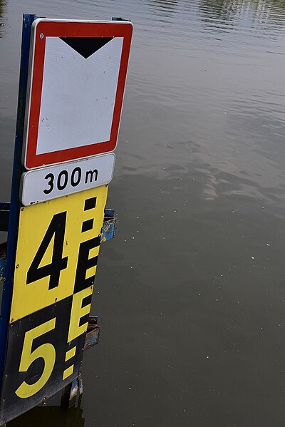
Français : Signalisation fluviale Basse-Deûle, entre Lille et confluence Lys. Il s'agit de la section terminale du canal avant passage en Belgique, soit une quinzaine de km.
Ici hauteur limitée mais, pas de panique, la voie d'eau est classée cat. V selon normes CEMT. Les ouvrages doivent donc offrir un dégagement minimal de 5,25 m au passage des navires. C'est plus simple qu'en transport routier où l'harmonisation est beaucoup moins poussée, les gabarits étant obligatoirement signalés sous 4,30 m. Quant au tirant d'eau, c'est-à-dire la profondeur maximale du chenal exploitable, il approche 3,5 m par endroits. |
| Date | |
| Source | Own work |
| Author | Dacia 1410 Sport |
Licensing edit
I, the copyright holder of this work, hereby publish it under the following license:
This file is licensed under the Creative Commons Attribution-Share Alike 4.0 International license.
- You are free:
- to share – to copy, distribute and transmit the work
- to remix – to adapt the work
- Under the following conditions:
- attribution – You must give appropriate credit, provide a link to the license, and indicate if changes were made. You may do so in any reasonable manner, but not in any way that suggests the licensor endorses you or your use.
- share alike – If you remix, transform, or build upon the material, you must distribute your contributions under the same or compatible license as the original.
File history
Click on a date/time to view the file as it appeared at that time.
| Date/Time | Thumbnail | Dimensions | User | Comment | |
|---|---|---|---|---|---|
| current | 03:46, 6 September 2023 | | 660 × 988 (177 KB) | Dacia 1410 Sport (talk | contribs) | Uploaded own work with UploadWizard |
You cannot overwrite this file.
File usage on Commons
There are no pages that use this file.