File:Proposed Dunstable and Luton Northern Bypass.png
No higher resolution available.
Proposed_Dunstable_and_Luton_Northern_Bypass.png (658 × 440 pixels, file size: 125 KB, MIME type: image/png)
Captions
Captions
Add a one-line explanation of what this file represents
Summary
edit
| Description |
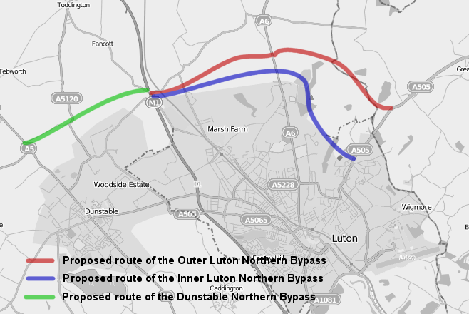
English: A map displaying the proposed Dunstable Northern Bypass, in green and the proposed inner route, in blue, and outer route, in red, of the Luton Northern Bypass. Overlaid on OpenStreetMap data. |
| Date | |
| Source | Own work over OpenStreetMap data. |
| Author | user:HelioSmith, OpenStreetMap |
Licensing
edit
This file is licensed under the Creative Commons Attribution-Share Alike 3.0 Unported license.
- You are free:
- to share – to copy, distribute and transmit the work
- to remix – to adapt the work
- Under the following conditions:
- attribution – You must give appropriate credit, provide a link to the license, and indicate if changes were made. You may do so in any reasonable manner, but not in any way that suggests the licensor endorses you or your use.
- share alike – If you remix, transform, or build upon the material, you must distribute your contributions under the same or compatible license as the original.
File history
Click on a date/time to view the file as it appeared at that time.
| Date/Time | Thumbnail | Dimensions | User | Comment | |
|---|---|---|---|---|---|
| current | 14:08, 22 July 2009 | | 658 × 440 (125 KB) | HelioSmith (talk | contribs) | {{Information |Description={{en|1=A map displaying the proposed Dunstable Northern Bypass, in green and the proposed inner route, in blue, and outer route, in red, of the Luton Northern Bypass. Overlaid on [http://www.openstreetmap.org/ OpenStreetMap] dat |
You cannot overwrite this file.
File usage on Commons
There are no pages that use this file.
File usage on other wikis
The following other wikis use this file:
- Usage on en.wikipedia.org