File:Ptolemy's Map of Taprobane.jpg
Size of this preview: 632 × 599 pixels. Other resolutions: 253 × 240 pixels | 506 × 480 pixels | 641 × 608 pixels.
Original file (641 × 608 pixels, file size: 86 KB, MIME type: image/jpeg)
Captions
Captions
Add a one-line explanation of what this file represents
Summary edit

Licensing edit
|
This is a faithful photographic reproduction of a two-dimensional, public domain work of art. The work of art itself is in the public domain for the following reason:
The official position taken by the Wikimedia Foundation is that "faithful reproductions of two-dimensional public domain works of art are public domain".
This photographic reproduction is therefore also considered to be in the public domain in the United States. In other jurisdictions, re-use of this content may be restricted; see Reuse of PD-Art photographs for details. | ||||
File history
Click on a date/time to view the file as it appeared at that time.
| Date/Time | Thumbnail | Dimensions | User | Comment | |
|---|---|---|---|---|---|
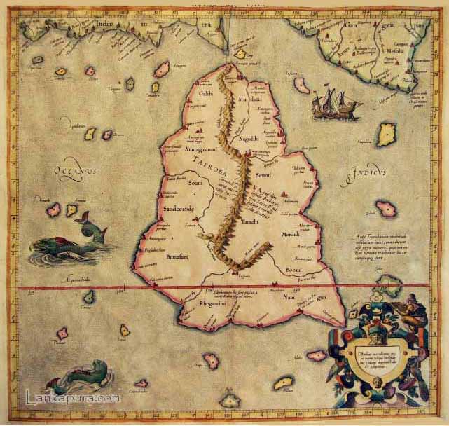
| current | 17:22, 20 August 2011 | | 641 × 608 (86 KB) | Astronomyinertia (talk | contribs) | {{Information |Description ={{en|1=Claudius Ptolemy's 1st century map of Taprobane (Sri Lanka).}} |Source =http://www.contourline.lk/en/history.php |Author =Claudius Ptolemy |Date =1st century AD |Permission = |other_versi |
You cannot overwrite this file.
File usage on Commons
The following page uses this file:
File usage on other wikis
The following other wikis use this file:
- Usage on de.wikipedia.org
- Usage on en.wikipedia.org
- Usage on eo.wikipedia.org
- Usage on es.wikipedia.org
- Usage on it.wikipedia.org
- Usage on pl.wikipedia.org
- Usage on ta.wikipedia.org
- Usage on zh.wikipedia.org