File:Puerto de Veracruz Desastre Huracan Karl 2010.png

Size of this preview: 468 × 599 pixels. Other resolutions: 187 × 240 pixels | 631 × 808 pixels.
Original file (631 × 808 pixels, file size: 323 KB, MIME type: image/png)
Captions
Captions
Add a one-line explanation of what this file represents
Summary edit
| Description |
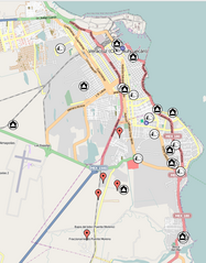
English: Map of the Veracruz City (Puerto de Veracruz) due to the Hurricane Karl Disaster in September 2010. Drastical floods took place with several parts of the City and other Regions several damaged. Hundreds of people were affected.
Mark descriptions: Red mark, Incidents reported; Black houses, Warehouses; Camping tents, Shelters; Blue dots, multiple. The information in the map is not completed. Many particulars and organization as well as the government of the State of Veracruz make efforts and support facilities, nevertheless anyone is to be known to have a complete report of such information. The information was taken from the local media, mainly internet web pages of local newspapers and radio station "XEU de Veracruz". The information is detailed in the referenced website (source). |
| Date | |
| Source | Veracruz Disaster Site from Sahanafoundation |
| Author | Gengiskanhg |
| Camera location | | View this and other nearby images on: OpenStreetMap |
|---|
Licensing edit
This file is licensed under the Creative Commons Attribution 3.0 Unported license.
- You are free:
- to share – to copy, distribute and transmit the work
- to remix – to adapt the work
- Under the following conditions:
- attribution – You must give appropriate credit, provide a link to the license, and indicate if changes were made. You may do so in any reasonable manner, but not in any way that suggests the licensor endorses you or your use.
File history
Click on a date/time to view the file as it appeared at that time.
| Date/Time | Thumbnail | Dimensions | User | Comment | |
|---|---|---|---|---|---|
| current | 21:07, 2 November 2010 | | 631 × 808 (323 KB) | Gengiskanhg (talk | contribs) | Using OpenStreetMaps instead of google in order to avoid possible license problems. |
| 20:52, 2 November 2010 |  | 665 × 829 (431 KB) | Gengiskanhg (talk | contribs) | {{Information |Description={{en|1=Map of the Veracruz City (Puerto de Veracruz) due to the Huricane Karl Disaster in September 2010. Drastical floods took place with several parts of the City and other Regions several damaged. Hundreds of people were affe |
You cannot overwrite this file.
File usage on Commons
There are no pages that use this file.
File usage on other wikis
The following other wikis use this file:
- Usage on es.wikipedia.org