File:Purley Way, Croydon - geograph.org.uk - 601438.jpg
No higher resolution available.
Purley_Way,_Croydon_-_geograph.org.uk_-_601438.jpg (640 × 496 pixels, file size: 67 KB, MIME type: image/jpeg)
Captions
Captions
Add a one-line explanation of what this file represents
Summary
edit
| Description |
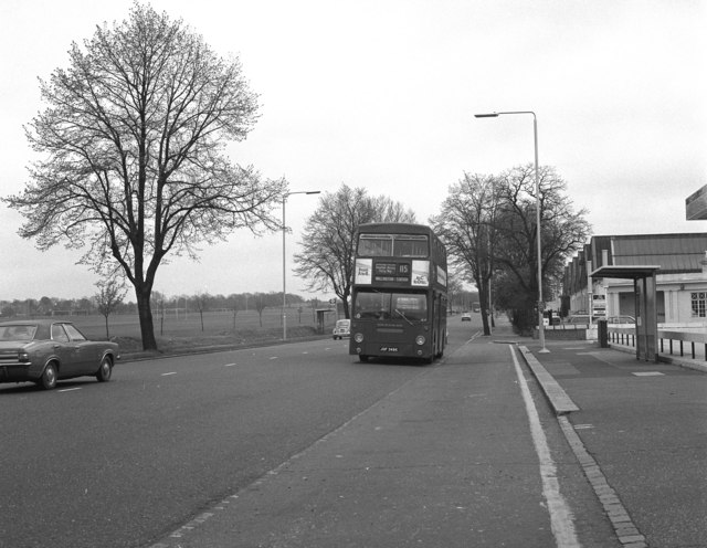
English: Purley Way, Croydon Purley Way was originally intended as a Croydon Bypass, and this 1981 photograph shows a part of it that did retain some such features. The scene here has vastly changed now in 2007 with many more buildings and a dual carriageway as many businesses hve been established. The playing fields, however, still remain.
In this photograph the DMS class bus is on Route 115, Whyteleafe to Wallington, a route which has long since vanished. |
| Date | |
| Source | From geograph.org.uk |
| Author | Dr Neil Clifton |
| Attribution (required by the license) | Dr Neil Clifton / Purley Way, Croydon / |
| Camera location | | View this and other nearby images on: OpenStreetMap |
|---|
_heading:135.00&language=en)
| Object location | | View this and other nearby images on: OpenStreetMap |
|---|
_heading:135.00&language=en)
Licensing
edit

|
This image was taken from the Geograph project collection. See this photograph's page on the Geograph website for the photographer's contact details. The copyright on this image is owned by Dr Neil Clifton and is licensed for reuse under the Creative Commons Attribution-ShareAlike 2.0 license.
|
This file is licensed under the Creative Commons Attribution-Share Alike 2.0 Generic license.
Attribution: Dr Neil Clifton
- You are free:
- to share – to copy, distribute and transmit the work
- to remix – to adapt the work
- Under the following conditions:
- attribution – You must give appropriate credit, provide a link to the license, and indicate if changes were made. You may do so in any reasonable manner, but not in any way that suggests the licensor endorses you or your use.
- share alike – If you remix, transform, or build upon the material, you must distribute your contributions under the same or compatible license as the original.
File history
Click on a date/time to view the file as it appeared at that time.
| Date/Time | Thumbnail | Dimensions | User | Comment | |
|---|---|---|---|---|---|
| current | 00:04, 7 February 2011 | | 640 × 496 (67 KB) | GeographBot (talk | contribs) | == {{int:filedesc}} == {{Information |description={{en|1=Purley Way, Croydon Purley Way was originally intended as a Croydon Bypass, and this 1981 photograph shows a part of it that did retain some such features. The scene here has vastly changed now in |
You cannot overwrite this file.
File usage on Commons
There are no pages that use this file.