File:Pyynikki tampere panorama.jpg

Size of this preview: 800 × 107 pixels. Other resolutions: 320 × 43 pixels | 640 × 85 pixels | 1,024 × 137 pixels | 1,280 × 171 pixels | 12,000 × 1,600 pixels.
Original file (12,000 × 1,600 pixels, file size: 4.15 MB, MIME type: image/jpeg)
Captions
Captions
Add a one-line explanation of what this file represents
| Description |
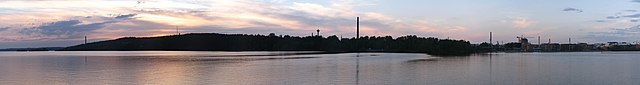
English: A panoramic view taken made from several pictures taken from Hatanpää park shore towards Pyynikki ridge covering about 260 degrees.
Suomi: Hatanpäänpuiston rannalta Pyynikin suuntaan otetusta kuvasarjasta koostettu panoramakuva, joka kattaa noin 260 astetta. |
||
| Date | |||
| Source | Own work | ||
| Author | Tuomas Palonen | ||
| Permission (Reusing this file) |
|
| Camera location | | View this and other nearby images on: OpenStreetMap |
|---|
| Annotations | This image is annotated: View the annotations at Commons |
File history
Click on a date/time to view the file as it appeared at that time.
| Date/Time | Thumbnail | Dimensions | User | Comment | |
|---|---|---|---|---|---|
| current | 21:40, 22 May 2010 | 12,000 × 1,600 (4.15 MB) | Ionwind (talk | contribs) | {{Information |Description={{en|1=A panoramic view taken made from several pictures taken from Hatanpää park shore towards Pyynikki ridge covering about 260 degrees.}} {{fi|1=Hatanpään puiston rannalta pyynikin suuntaan otetusta kuvasarjasta koostettu |
You cannot overwrite this file.
File usage on Commons
There are no pages that use this file.
File usage on other wikis
The following other wikis use this file:
- Usage on fi.wikivoyage.org
- Usage on www.wikidata.org