File:Queensland floods ESA19361524.tiff

Original file (12,108 × 9,166 pixels, file size: 317.54 MB, MIME type: image/tiff)
Captions
Captions
Summary edit
| Warning | The original file is very high-resolution. It might not load properly or could cause your browser to freeze when opened at full size. |
|---|
| Description |
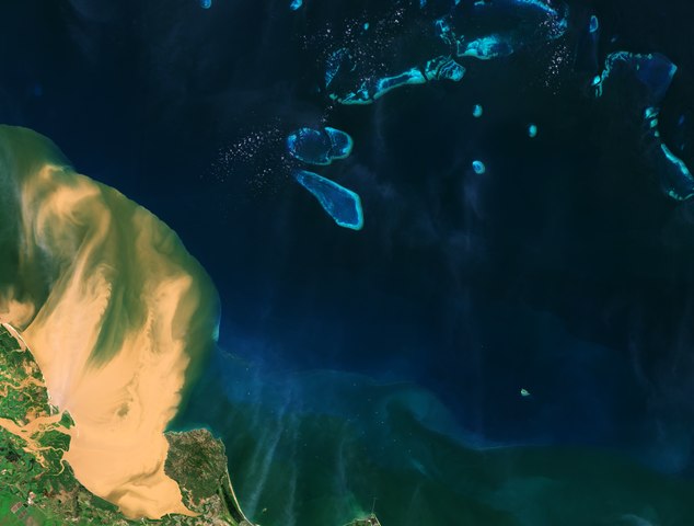
English: The Copernicus Sentinel-2 mission takes us over Australia’s northeast state of Queensland, where a large amount of sediment is visible gushing into the Coral Sea, close to the Great Barrier Reef lagoon. In early 2019, many areas in Queensland received more than their annual rainfall in less than a week. The downpour led to millions of dollars’ worth of damage, including homes being destroyed and the loss of almost 500 000 cattle. This image was captured a few days after the torrential rain, and shows the muddy waters flowing from the Burdekin River into the Coral Sea. The Burdekin River rises on the northern slopes of Boulder Mountain and flows close to 900 km before emptying into the Coral Sea. Burdekin River is one of Australia's larger rivers by discharge volume, and is a major contributor of sediment and freshwater to the Great Barrier Reef lagoon. The Great Barrier Reef, the world’s largest coral reef, extends for 2000 km along the northeast coast of Australia and covers almost 350 000 sq km. The reef is an interlinked system of about 3000 reefs and 900 coral islands, divided by narrow passages. An important area of biodiversity, the reef was made a UNESCO World Heritage Site in 1981. The sand-colour sediment plume can be seen stretching over 35 km from the coast, dangerously close to the vivid turquoise reef. The blues of the coral contrast with the dark-coloured waters of the Coral Sea. The reef suffers regular damage, more than half of the reef has disappeared over the last 30 years owing to climate change, coral bleaching and pollution. Large quantities of sediment that flow out from rivers carry chemicals and fertilisers from inland farms. The sediment blankets the coral, and reduces the amount of light, as well as potentially causing harmful algae blooms. Data from Copernicus Sentinel-2 plays a key role in providing information on pollution in lakes and coastal waters. Frequent coverage is also fundamental to monitoring floods. Copernicus Sentinel-2 is a two-satellite mission. Each satellite carries a high-resolution camera that images Earth’s surface in 13 spectral bands. This image, which was captured on 10 February 2019, is also featured on the Earth from Space video programme. |
| Date | 26 April 2019 (upload date) |
| Source | Queensland floods |
| Author | European Space Agency |
| Other versions |
|
| Activity | Observing the Earth |
| Mission | Sentinel-2 |
| Set | Earth observation image of the week |
| System | Copernicus |

Licensing edit

|
This image contains data from a satellite in the Copernicus Programme, such as Sentinel-1, Sentinel-2 or Sentinel-3. Attribution is required when using this image.
Attribution: Contains modified Copernicus Sentinel data 2019
The use of Copernicus Sentinel Data is regulated under EU law (Commission Delegated Regulation (EU) No 1159/2013 and Regulation (EU) No 377/2014). Relevant excerpts:
Free access shall be given to GMES dedicated data [...] made available through GMES dissemination platforms [...].
Access to GMES dedicated data [...] shall be given for the purpose of the following use in so far as it is lawful:
GMES dedicated data [...] may be used worldwide without limitations in time.
GMES dedicated data and GMES service information are provided to users without any express or implied warranty, including as regards quality and suitability for any purpose. |
This media was created by the European Space Agency (ESA).
Where expressly so stated, images or videos are covered by the Creative Commons Attribution-ShareAlike 3.0 IGO (CC BY-SA 3.0 IGO) licence, ESA being an Intergovernmental Organisation (IGO), as defined by the CC BY-SA 3.0 IGO licence. The user is allowed under the terms and conditions of the CC BY-SA 3.0 IGO license to Reproduce, Distribute and Publicly Perform the ESA images and videos released under CC BY-SA 3.0 IGO licence and the Adaptations thereof, without further explicit permission being necessary, for as long as the user complies with the conditions and restrictions set forth in the CC BY-SA 3.0 IGO licence, these including that:
See the ESA Creative Commons copyright notice for complete information, and this article for additional details.
|
 | |
This file is licensed under the Creative Commons Attribution-ShareAlike 3.0 IGO license. Attribution: ESA, CC BY-SA IGO 3.0
| ||
File history
Click on a date/time to view the file as it appeared at that time.
| Date/Time | Thumbnail | Dimensions | User | Comment | |
|---|---|---|---|---|---|
| current | 10:21, 10 June 2020 |  | 12,108 × 9,166 (317.54 MB) | OptimusPrimeBot (talk | contribs) | #Spacemedia - Upload of http://esamultimedia.esa.int/img/2019/04/queensland_S2_10feb2019_432_ML.tif via Commons:Spacemedia |
You cannot overwrite this file.
File usage on Commons
The following page uses this file: