File:ROCK WORK AT SUNRISE POINT TURN; MOUNT RAINIER IN BACKGROUND; VIEW FACING SOUTHWEST - Yakima Park Highway, Between Mather Memorial Parkway and Yakima Park, Longmire, Pierce HAER WASH,27-LONG.V,26-2.tif

Size of this JPG preview of this TIF file: 800 × 578 pixels. Other resolutions: 320 × 231 pixels | 640 × 462 pixels | 1,024 × 740 pixels | 1,280 × 924 pixels | 2,560 × 1,849 pixels | 5,000 × 3,611 pixels.
Original file (5,000 × 3,611 pixels, file size: 17.22 MB, MIME type: image/tiff)
Captions
Captions
Add a one-line explanation of what this file represents
Summary edit
| ROCK WORK AT SUNRISE POINT TURN; MOUNT RAINIER IN BACKGROUND; VIEW FACING SOUTHWEST - Yakima Park Highway, Between Mather Memorial Parkway and Yakima Park, Longmire, Pierce County, WA | ||||
|---|---|---|---|---|
| Photographer |
Lowe, Jet, creator |
|||
| Title |
ROCK WORK AT SUNRISE POINT TURN; MOUNT RAINIER IN BACKGROUND; VIEW FACING SOUTHWEST - Yakima Park Highway, Between Mather Memorial Parkway and Yakima Park, Longmire, Pierce County, WA |
|||
| Description |
Bureau of Public Roads; Mount Rainier Mining Company; Toll, Roger W; Tomlinson, Owen A; Short, C R; Goerig, A C; Lidral Construction Company; John Strom and Company; Emergency Conservation Works; Quin, Richard H, historian; Lowe, Jet, photographer |
|||
| Depicted place | Washington; Pierce County; Longmire | |||
| Date | 1992 | |||
| Dimensions | 5 x 7 in. | |||
| Current location |
Library of Congress Prints and Photographs Division Washington, D.C. 20540 USA http://hdl.loc.gov/loc.pnp/pp.print |
|||
| Accession number |
HAER WASH,27-LONG.V,26-2 |
|||
| Credit line |
|
|||
| Notes |
|
|||
| Source | https://www.loc.gov/pictures/item/wa0353.photos.369980p | |||
| Permission (Reusing this file) |
|
|||

| Camera location | | View this and other nearby images on: OpenStreetMap |
|---|
File history
Click on a date/time to view the file as it appeared at that time.
| Date/Time | Thumbnail | Dimensions | User | Comment | |
|---|---|---|---|---|---|
| current | 20:27, 4 August 2014 | 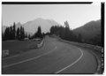 | 5,000 × 3,611 (17.22 MB) | Fæ (talk | contribs) | GWToolset: Creating mediafile for Fæ. HABS 2014-08-04 (3601:3800) Penultimate Tranche! |
You cannot overwrite this file.
File usage on Commons
The following page uses this file: