File:Radargramm2.png
No higher resolution available.
Radargramm2.png (760 × 327 pixels, file size: 125 KB, MIME type: image/png)
Captions
Captions
Add a one-line explanation of what this file represents
Source: de:Radargramm.png
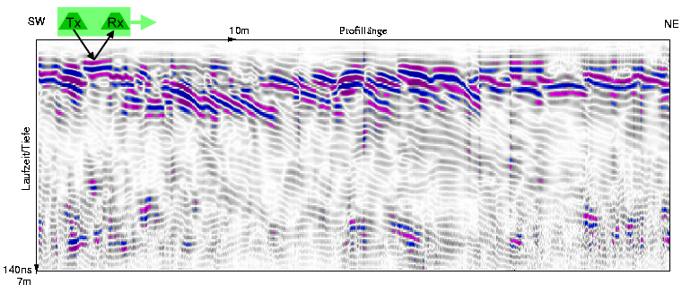
- Beschreibung: Georadar-Profil (Vorschüttungsstrukturen, Oberschwaben)
- Quelle: Schuh, M.: Würmzeitliche Ablagerungen im Gebiet um Fronhofen/Oberschwaben, 2003
- Fotograf oder Zeichner: M.Schuh
- Andere Versionen:
- Lizenzstatus: GNU FDL
Slightly extended by Abrev 15:32, 8 February 2008 (UTC)

|
Permission is granted to copy, distribute and/or modify this document under the terms of the GNU Free Documentation License, Version 1.2 or any later version published by the Free Software Foundation; with no Invariant Sections, no Front-Cover Texts, and no Back-Cover Texts. A copy of the license is included in the section entitled GNU Free Documentation License. |
| This file is licensed under the Creative Commons Attribution-Share Alike 3.0 Unported license. | ||
| ||
| This licensing tag was added to this file as part of the GFDL licensing update. |
related image: Image:LINE21.jpg
File history
Click on a date/time to view the file as it appeared at that time.
| Date/Time | Thumbnail | Dimensions | User | Comment | |
|---|---|---|---|---|---|
| current | 15:32, 8 February 2008 | | 760 × 327 (125 KB) | Abrev (talk | contribs) | Source: de:Radargramm.png *Beschreibung: Georadar-Profil (Vorschüttungsstrukturen, Oberschwaben) *Quelle: Schuh, M.: ''Würmzeitliche Ablagerungen im Gebiet um Fronhofen/Oberschwaben'', 2003 *Fotograf oder Zeichner: M.Schuh *Andere Versionen: *Liz |
You cannot overwrite this file.
File usage on Commons
There are no pages that use this file.
File usage on other wikis
The following other wikis use this file:
- Usage on de.wikipedia.org
- Usage on nds.wikipedia.org