File:Rail map scotland 2014.png
Size of this preview: 363 × 600 pixels. Other resolutions: 145 × 240 pixels | 290 × 480 pixels | 465 × 768 pixels | 620 × 1,024 pixels | 1,349 × 2,229 pixels.
Original file (1,349 × 2,229 pixels, file size: 249 KB, MIME type: image/png)
Captions
Captions
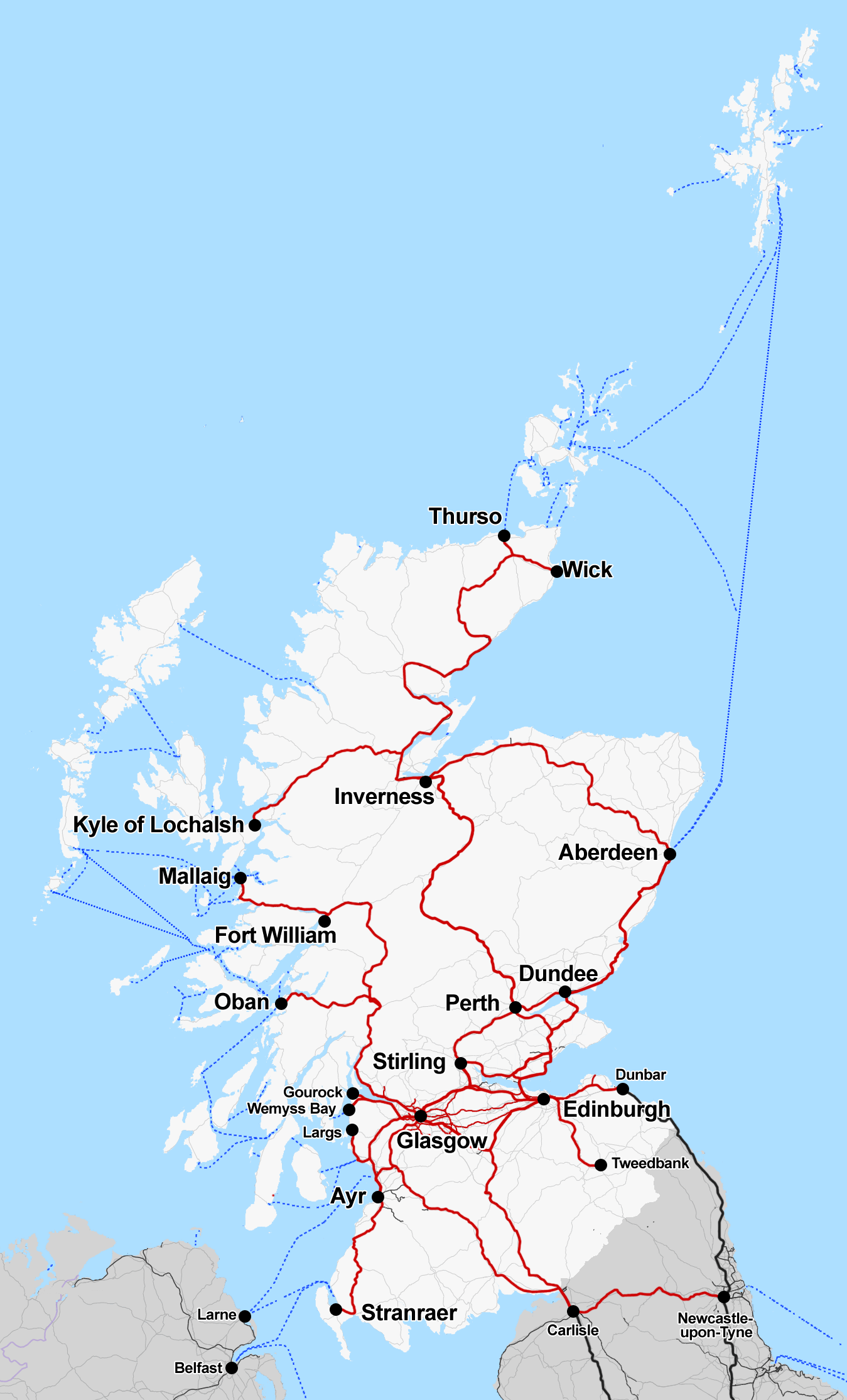
ScotRail Operating Route Map

|
This transport map image could be re-created using vector graphics as an SVG file. This has several advantages; see Commons:Media for cleanup for more information. If an SVG form of this image is available, please upload it and afterwards replace this template with
{{vector version available|new image name}}.
It is recommended to name the SVG file “Rail map scotland 2014.svg”—then the template Vector version available (or Vva) does not need the new image name parameter. |
Summary edit
| Description |
English: Map of the rail routes of Scotland in 2018, shown in red |
| Date | |
| Source | Own work |
| Author | Cnbrb |
| Description |
This map was created from OpenStreetMap project data, collected by the community. This map may be incomplete, and may contain errors. Don't rely solely on it for navigation. |
|||
| Date | (see file history) | |||
| Source | openstreetmap.org | |||
| Creator |
OpenStreetMap contributors |
|||
| Permission (Reusing this file) |
OpenStreetMap data is available under the Open Database License (details). Map tiles are licensed under the Creative Commons Attribution-ShareAlike 2.0 license (CC-BY-SA 2.0).
This file is licensed under the Creative Commons Attribution-Share Alike 2.0 Generic license.
|
|||
| Georeferencing | If inappropriate please set warp_status = skip to hide. |
Licensing edit
I, the copyright holder of this work, hereby publish it under the following license:
| This file is made available under the Creative Commons CC0 1.0 Universal Public Domain Dedication. | |
| The person who associated a work with this deed has dedicated the work to the public domain by waiving all of their rights to the work worldwide under copyright law, including all related and neighboring rights, to the extent allowed by law. You can copy, modify, distribute and perform the work, even for commercial purposes, all without asking permission.
|
File history
Click on a date/time to view the file as it appeared at that time.
| Date/Time | Thumbnail | Dimensions | User | Comment | |
|---|---|---|---|---|---|
| current | 15:14, 3 April 2018 | | 1,349 × 2,229 (249 KB) | Cnbrb (talk | contribs) | show Waverley Line as solid line, since it actually opened 3 years ago |
| 22:15, 4 July 2015 |  | 1,349 × 2,229 (436 KB) | Cmdrjameson (talk | contribs) | Compressed with pngout. Reduced by 315kB (41% decrease). | |
| 17:34, 20 August 2014 |  | 1,349 × 2,229 (752 KB) | Cnbrb (talk | contribs) | User created page with UploadWizard |
You cannot overwrite this file.
File usage on Commons
The following 11 pages use this file:
- User:Chumwa/OgreBot/Potential transport maps/2018 April 1-10
- User:Chumwa/OgreBot/Public transport information/2014 August 11-20
- User:Chumwa/OgreBot/Public transport information/2015 July 1-10
- User:Chumwa/OgreBot/Public transport information/2018 April 1-10
- User:Chumwa/OgreBot/Transport Maps/2014 August 11-20
- User:Chumwa/OgreBot/Transport Maps/2015 July 1-10
- User:Chumwa/OgreBot/Transport Maps/2018 April 1-10
- User:Chumwa/OgreBot/Travel and communication maps/2018 April 1-10
- User:Mattbuck/Railways/2014 August 11-20
- User:Mattbuck/Railways/2015 July 1-10
- User:Mattbuck/Railways/2018 April 1-10
File usage on other wikis
The following other wikis use this file:
- Usage on de.wikipedia.org
- Usage on en.wikipedia.org
- Usage on zh.wikipedia.org