File:Railcu.svg

Size of this PNG preview of this SVG file: 562 × 600 pixels. Other resolutions: 225 × 240 pixels | 450 × 480 pixels | 720 × 768 pixels | 960 × 1,024 pixels | 1,920 × 2,048 pixels | 1,677 × 1,789 pixels.
Original file (SVG file, nominally 1,677 × 1,789 pixels, file size: 864 KB)
Captions
Captions
Add a one-line explanation of what this file represents
| Description |
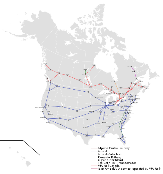
English: An attempt to create single passenger rail map of Canada and the USA (Mexico has no regular passenger trains that I am aware of). This map is supposed to be practical and simple while aesthetically pleasing. I chose passenger rail because of sparseness and the ease of monitoring changes to service. I have chosen to exclude tourist and commuter trains. Feel free to improve on my design. |
| Date | (UTC) |
| Source |
This W3C-unspecified vector image was created with Inkscape . |
| Author |
|
I, the copyright holder of this work, hereby publish it under the following licenses:
This file is licensed under the Creative Commons Attribution-Share Alike 3.0 Unported license.
- You are free:
- to share – to copy, distribute and transmit the work
- to remix – to adapt the work
- Under the following conditions:
- attribution – You must give appropriate credit, provide a link to the license, and indicate if changes were made. You may do so in any reasonable manner, but not in any way that suggests the licensor endorses you or your use.
- share alike – If you remix, transform, or build upon the material, you must distribute your contributions under the same or compatible license as the original.

|
Permission is granted to copy, distribute and/or modify this document under the terms of the GNU Free Documentation License, Version 1.2 or any later version published by the Free Software Foundation; with no Invariant Sections, no Front-Cover Texts, and no Back-Cover Texts. A copy of the license is included in the section entitled GNU Free Documentation License. |
You may select the license of your choice.
Original upload log edit
This image is a derivative work of the following images:
- File:BlankMap-North_America-Subdivisions.svg licensed with Cc-by-sa-3.0, GFDL
- 2010-05-20T18:15:23Z NuclearVacuum 1677x1789 (1239660 Bytes) added Hawaii
- 2010-05-20T17:55:52Z NuclearVacuum 1677x1789 (1214990 Bytes) {{Information |Description={{en|1=A new version of the subdivisions of the United States, Canada, and Mexico. {{ValidSVG}}}} |Source={{own}}{{Inkscape}} |Author=[[User:NuclearVacuum|NuclearVacuum]] |Date=2010 |Permission= |ot
Uploaded with derivativeFX
File history
Click on a date/time to view the file as it appeared at that time.
| Date/Time | Thumbnail | Dimensions | User | Comment | |
|---|---|---|---|---|---|
| current | 00:51, 25 November 2010 | | 1,677 × 1,789 (864 KB) | Samuell (talk | contribs) | fix Amtrak Silver star |
| 03:50, 21 November 2010 |  | 1,677 × 1,789 (863 KB) | Samuell (talk | contribs) | {{Information |Description={{en|1=An attempt to create single passenger rail map of Canada and the USA (Mexico has no regular passenger trains that I am aware of). This map is supposed to be practical and simple while aesthetically pleasing. I chose pass |
You cannot overwrite this file.
File usage on Commons
There are no pages that use this file.