File:Railway bridge at Welsh Hook - geograph.org.uk - 1508875.jpg
No higher resolution available.
Railway_bridge_at_Welsh_Hook_-_geograph.org.uk_-_1508875.jpg (640 × 480 pixels, file size: 126 KB, MIME type: image/jpeg)
Captions
Captions
Add a one-line explanation of what this file represents
Summary edit
| Description |
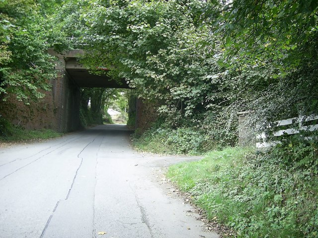
English: Railway bridge at Welsh Hook Railway bridge over a minor road at Welsh Hook on the way to joining the A40 between Letterston and Wolf's Castle. There was a railway halt called Welsh Hook for St.Lawrence by the railway bridge. This is indicated as a halt on the old 1940s OS map. At Welsh Hook Halt, the passenger would have to stick his or her hand out frantically to request the driver to stop the train! The halt was opened in the early 1920s and was closed in 1964, along with the other halts at Jordanston, Mathry Road near Letterston and Wolf's Castle between Fishguard Harbour and Clarbeston Road stations. |
| Date | |
| Source | From geograph.org.uk |
| Author | Martyn Harries |
| Attribution (required by the license) | Martyn Harries / Railway bridge at Welsh Hook / |
| Camera location | | View this and other nearby images on: OpenStreetMap |
|---|
_heading:45.00&language=en)
| Object location | | View this and other nearby images on: OpenStreetMap |
|---|
_heading:45.00&language=en)
Licensing edit

|
This image was taken from the Geograph project collection. See this photograph's page on the Geograph website for the photographer's contact details. The copyright on this image is owned by Martyn Harries and is licensed for reuse under the Creative Commons Attribution-ShareAlike 2.0 license.
|
This file is licensed under the Creative Commons Attribution-Share Alike 2.0 Generic license.
Attribution: Martyn Harries
- You are free:
- to share – to copy, distribute and transmit the work
- to remix – to adapt the work
- Under the following conditions:
- attribution – You must give appropriate credit, provide a link to the license, and indicate if changes were made. You may do so in any reasonable manner, but not in any way that suggests the licensor endorses you or your use.
- share alike – If you remix, transform, or build upon the material, you must distribute your contributions under the same or compatible license as the original.
File history
Click on a date/time to view the file as it appeared at that time.
| Date/Time | Thumbnail | Dimensions | User | Comment | |
|---|---|---|---|---|---|
| current | 21:26, 2 March 2011 | | 640 × 480 (126 KB) | GeographBot (talk | contribs) | == {{int:filedesc}} == {{Information |description={{en|1=Railway bridge at Welsh Hook Railway bridge over a minor road at Welsh Hook on the way to joining the A40 between Letterston and Wolf's Castle. There was a railway halt called Welsh Hook for St.Lawr |
You cannot overwrite this file.
File usage on Commons
There are no pages that use this file.
File usage on other wikis
The following other wikis use this file:
- Usage on en.wikipedia.org