File:Rainfall from Roanu in Bay of Bengal.png

Size of this preview: 800 × 600 pixels. Other resolutions: 320 × 240 pixels | 640 × 480 pixels | 1,024 × 768 pixels | 1,280 × 960 pixels | 1,740 × 1,305 pixels.
Original file (1,740 × 1,305 pixels, file size: 2.49 MB, MIME type: image/png)
Captions
Captions
Add a one-line explanation of what this file represents
Summary
edit
| Description |
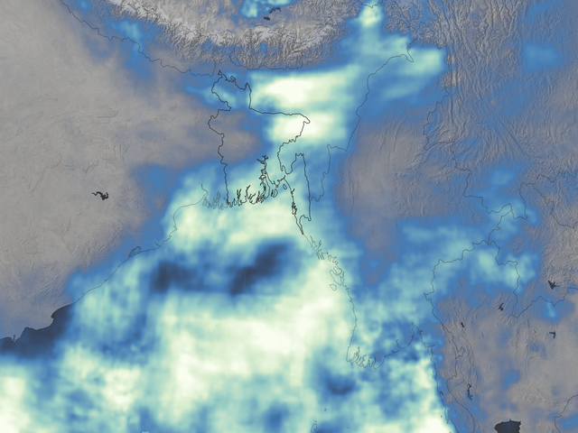
English: The map shows a satellite-based estimate of rainfall from May 15-22, 2016. The data come from the Integrated Multi-Satellite Retrievals for GPM (IMERG), a product of the Global Precipitation Measurement mission. The brightest shades on the maps represent rainfall totals of at least 800 millimeters (more than 30 inches) during that period. Blue areas saw less rain, and gray areas received no rain. These regional, remotely-sensed estimates may differ from the totals measured by ground-based weather stations. |
| Date | |
| Source | https://earthobservatory.nasa.gov/NaturalHazards/view.php?id=88074 |
| Author | NASA |
Licensing
edit
| This file is in the public domain in the United States because it was solely created by NASA. NASA copyright policy states that "NASA material is not protected by copyright unless noted". (See Template:PD-USGov, NASA copyright policy page or JPL Image Use Policy.) | ||
 |
Warnings:
|
File history
Click on a date/time to view the file as it appeared at that time.
| Date/Time | Thumbnail | Dimensions | User | Comment | |
|---|---|---|---|---|---|
| current | 12:37, 19 March 2018 | | 1,740 × 1,305 (2.49 MB) | A1Cafel (talk | contribs) | User created page with UploadWizard |
You cannot overwrite this file.
File usage on Commons
The following page uses this file: