File:Rankin River.jpg

Size of this preview: 800 × 534 pixels. Other resolutions: 320 × 213 pixels | 640 × 427 pixels | 1,024 × 683 pixels.
Original file (1,024 × 683 pixels, file size: 402 KB, MIME type: image/jpeg)
Captions
Captions
Add a one-line explanation of what this file represents
Summary edit
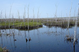
| Description | Located at the waist of the Bruce Peninsula, sections of the present day canoe route were utilized for hundreds of years by Indians traveling between Georgian Bay and Lake Huron. Missionaries and early settlers also used the route to avoid the long, perilous journey by water around the Bruce Peninsula. Lumbering reached the area in the 1860's. Square timber and saw logs were floated down the Rankin River to Lake Huron. Twenty years later, the steamer "Water Witch" towed rafts of saw logs from Sky, Isaac, and Boat Lakes towards the mill at Sauble Falls. In an attempt to reclaim possible agricultural land, a 1921 drainage project was abandoned when the soil was found to be unworkable. In 1961, the Sauble Valley Conservation Authority constructed a dam on the lower Rankin River to control the wildly fluctuating lake levels and to restore the valuable wetland habitat for increased wildlife potential. This trip is a must for anyone with an interest in viewing flora and fauna in its natural habitat. Basic canoeing or kayaking skill is recommended. |
| Date | |
| Source |
|
| Author | Jocelyn from Mississauga, Canada |
Licensing edit
This file is licensed under the Creative Commons Attribution 2.0 Generic license.
- You are free:
- to share – to copy, distribute and transmit the work
- to remix – to adapt the work
- Under the following conditions:
- attribution – You must give appropriate credit, provide a link to the license, and indicate if changes were made. You may do so in any reasonable manner, but not in any way that suggests the licensor endorses you or your use.
| This image, originally posted to Flickr, was reviewed on July 4, 2011 by the administrator or reviewer File Upload Bot (Magnus Manske), who confirmed that it was available on Flickr under the stated license on that date. |
File history
Click on a date/time to view the file as it appeared at that time.
| Date/Time | Thumbnail | Dimensions | User | Comment | |
|---|---|---|---|---|---|
| current | 04:01, 4 July 2011 | | 1,024 × 683 (402 KB) | File Upload Bot (Magnus Manske) (talk | contribs) | {{Information |Description=Located at the waist of the Bruce Peninsula, sections of the present day canoe route were utilized for hundreds of years by Indians traveling between Georgian Bay and Lake Huron. Missionaries and early settlers also used the rou |
You cannot overwrite this file.
File usage on Commons
There are no pages that use this file.
File usage on other wikis
The following other wikis use this file:
- Usage on ceb.wikipedia.org
- Usage on en.wikipedia.org
- Usage on pt.wikipedia.org
- Usage on www.wikidata.org