File:Reģi Manor after fire , Reģu muiža pēc ugunsgrēka - panoramio (4).jpg
Original file (2,448 × 3,264 pixels, file size: 3.22 MB, MIME type: image/jpeg)
Captions
Summary edit
DescriptionReģi Manor after fire , Reģu muiža pēc ugunsgrēka - panoramio (4).jpg |
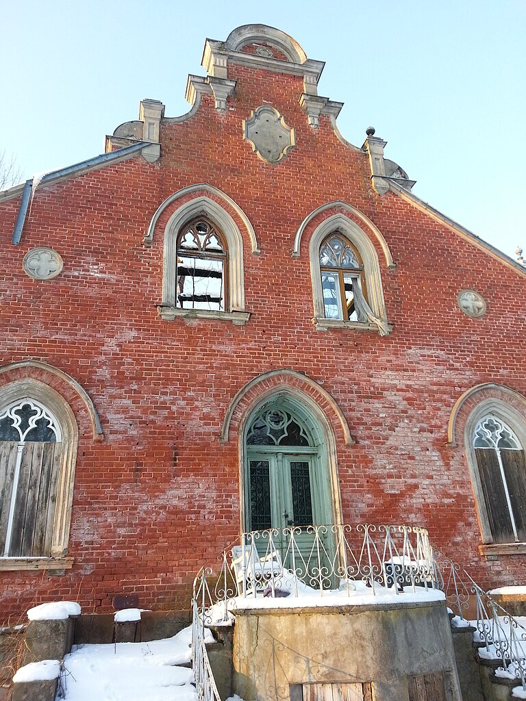
English: Reģi Manor after fire Latviešu: Reģu muiža pēc ugunsgrēka |
||
Date | Taken on 23 February 2013 | ||
Source | https://web.archive.org/web/20161026014157/http://www.panoramio.com/photo/86536108 | ||
Author | Maris Teteris | ||
Permission (Reusing this file) |
This file is licensed under the Creative Commons Attribution 3.0 Unported license. Attribution: Maris Teteris
|
||
Tags (from Panoramio photo page) InfoField | Alsungas novads , 2013 , Alsunga , Alsunga municipality , Alsungas novads , Latvia , Reģi , Suiti |
Camera location | 56° 59′ 44″ N, 21° 37′ 18″ E | View this and other nearby images on: OpenStreetMap | 56.995556; 21.621667 |
---|
File history
Click on a date/time to view the file as it appeared at that time.
Date/Time | Thumbnail | Dimensions | User | Comment | |
---|---|---|---|---|---|
current | 18:47, 9 February 2017 | 2,448 × 3,264 (3.22 MB) | Panoramio upload bot (talk | contribs) | == {{int:filedesc}} == {{Information |description=Reģi Manor after fire | Reģu muiža pēc ugunsgrēka |date={{Taken on|2013-02-23}} |source=http://www.panoramio.com/photo/86536108 |author=[http://www.panoramio.com/user/1763701?with_photo_id=86536108... |
You cannot overwrite this file.
File usage on Commons
There are no pages that use this file.
Metadata
This file contains additional information such as Exif metadata which may have been added by the digital camera, scanner, or software program used to create or digitize it. If the file has been modified from its original state, some details such as the timestamp may not fully reflect those of the original file. The timestamp is only as accurate as the clock in the camera, and it may be completely wrong.
Camera manufacturer | SAMSUNG |
---|---|
Camera model | GT-I9300 |
Exposure time | 1/141 sec (0.0070921985815603) |
F-number | f/2.6 |
ISO speed rating | 80 |
Date and time of data generation | 16:56, 23 February 2013 |
Lens focal length | 3.7 mm |
User comments | K$SxV4xV4xV4xV4`é41èÿÿlåÍ„ýýCALZDFE02Cur.ZDFI02CML018001001509FD0901090109010D010D010D090Dï%eë&'TUNAÐ$ì
ìi)’nÛ–iWÿÿ¼Ùÿÿ)LÓÚÿÿ:}\ÿÿI—FLFLSVN# ®Ð$ô ììô R Z ) ÖR®Ò 8JKJK û5þlpM‘ÂB…$ì(>oi)’nÛ–iWÿÿ¼Ùÿÿ)LÓÚÿÿ:}\ÿÿI—JKJKˆˆˆˆˆ€ € € € "‘€ € ""ˆˆˆˆˆ€ € € € ‘€ € € "‘ˆˆˆˆˆ€ € € € € € € € "‘ˆˆˆˆ™ € € € € € € € € ""‘ˆˆˆ"€ ppp€ € € € € "`pˆˆˆ€ € ‘"€ € € € ppppˆ"€ € € € € € € ‘"""ppˆ€ € p€ € € € € """"`pˆ€ € € € pp€ € ‘‘€ ‘‘``ˆ€ € € € ""€ € € € € € p‘‘ˆˆ"€ € ""€ € € € € € p""ˆˆ"€ € € € € € € € € € € ""ˆˆˆ™ € € € € € € € € € € ""ˆˆˆˆ€ € € € € € € € € € ""ˆˆˆˆ€ € € € € "‘pp€ "ˆˆˆˆ"€ € € € """€ p€ JKJK ÷ÿRxp]÷ÿ?M:÷ž¡jêÿÿÕ~a(ïÿ»nù'ïÿ&où'ïÿ&où'ïÿ&o ýAFAFXQX,¡ö=Ž¨=7£`""'¿–}B‡¼äÒ«äy‡&!h&,?ëE(ºØEDÃ:`0Qô`Je{%&Ù{BZ kkd1´dJ:ª]-Ù]HTvV$Û°VBŠŸd0?œdKAIIIIIIIIIIAFAF@ZDdiAFAFäÞ°ô€ X ¤xR¼)Þ)Þss\&ºÆ³6nëëíïñóΊFß›WðÞ¼š?44HGx@ýÿ?ï |
Latitude | 56° 59′ 44″ N |
Longitude | 21° 37′ 18″ E |
Altitude | 93 meters above sea level |
Width | 3,264 px |
Height | 2,448 px |
Orientation | Rotated 90° CCW |
Horizontal resolution | 72 dpi |
Vertical resolution | 72 dpi |
Software used | I9300XXELLA |
File change date and time | 16:56, 23 February 2013 |
Y and C positioning | Centered |
Exposure Program | Aperture priority |
Exif version | 2.2 |
Date and time of digitizing | 16:56, 23 February 2013 |
Meaning of each component |
|
APEX shutter speed | 7.140625 |
APEX aperture | 2.76 |
APEX brightness | 5.32421875 |
APEX exposure bias | 0 |
Maximum land aperture | 2.76 APEX (f/2.6) |
Metering mode | Spot |
Flash | Flash did not fire |
Supported Flashpix version | 1 |
Color space | sRGB |
Exposure mode | Auto exposure |
White balance | Auto white balance |
Scene capture type | Standard |
Unique image ID | ZDFI02 |
GPS time (atomic clock) | 14:54 |
GPS date | 23 February 2013 |
GPS tag version | 0.0.2.2 |