File:Red Arch Mtn.jpg
Size of this preview: 800 × 526 pixels. Other resolutions: 320 × 210 pixels | 640 × 421 pixels | 1,152 × 757 pixels.
Original file (1,152 × 757 pixels, file size: 468 KB, MIME type: image/jpeg)
File information
Structured data
Captions
Summary edit
DescriptionRed Arch Mtn.jpg |
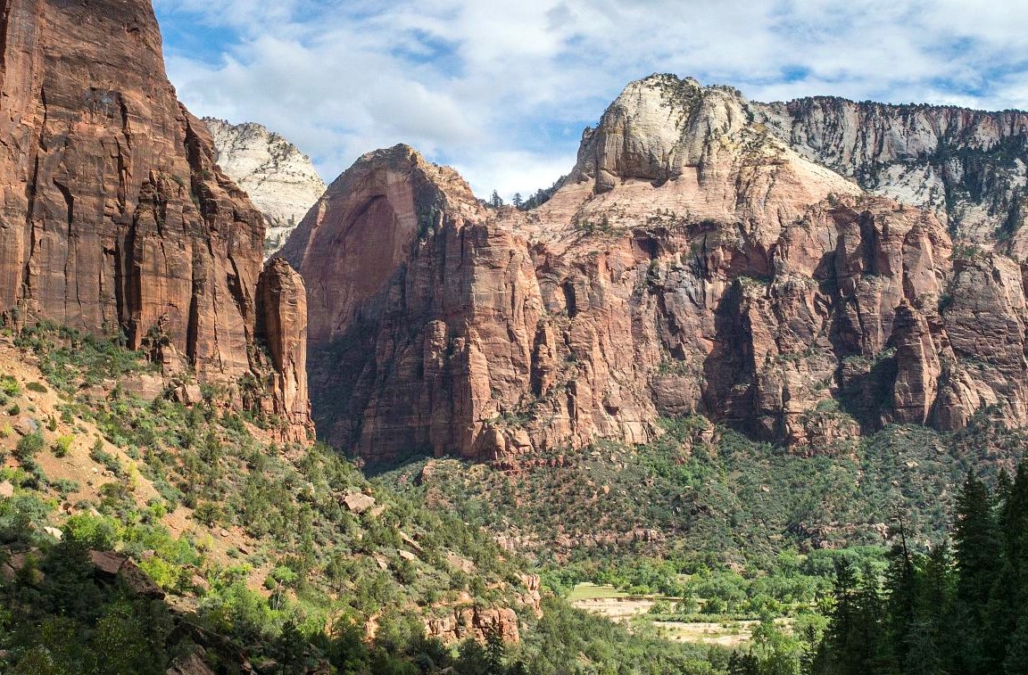
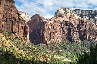
English: Red Arch Mountain from the west |
Date | Taken on 21 September 2014, 14:51:07 |
Source | File:Backroads Bryce & Zion (15342834196).jpg |
Author | Christopher Michel |
Camera location | 37° 15′ 28.88″ N, 112° 57′ 52.93″ W | View this and other nearby images on: OpenStreetMap | 37.258022; -112.964702 |
---|
Licensing edit
This file is licensed under the Creative Commons Attribution 2.5 Generic license.
- You are free:
- to share – to copy, distribute and transmit the work
- to remix – to adapt the work
- Under the following conditions:
- attribution – You must give appropriate credit, provide a link to the license, and indicate if changes were made. You may do so in any reasonable manner, but not in any way that suggests the licensor endorses you or your use.
Annotations InfoField | This image is annotated: View the annotations at Commons |
353
154
189
168
1152
757
Red Arch Mountain
File history
Click on a date/time to view the file as it appeared at that time.
Date/Time | Thumbnail | Dimensions | User | Comment | |
---|---|---|---|---|---|
current | 08:26, 6 September 2020 | 1,152 × 757 (468 KB) | Ron Clausen (talk | contribs) | Uploaded a work by Christopher Michel from File:Backroads Bryce & Zion (15342834196).jpg with UploadWizard |
You cannot overwrite this file.
File usage on Commons
The following page uses this file:
Metadata
This file contains additional information such as Exif metadata which may have been added by the digital camera, scanner, or software program used to create or digitize it. If the file has been modified from its original state, some details such as the timestamp may not fully reflect those of the original file. The timestamp is only as accurate as the clock in the camera, and it may be completely wrong.
Camera manufacturer | Leica Camera AG |
---|---|
Camera model | LEICA M (Typ 240) |
Author | Christopher Prentiss Michel |
Exposure time | 1/180 sec (0.0055555555555556) |
F-number | f/32 |
ISO speed rating | 1,000 |
Date and time of data generation | 14:51, 21 September 2014 |
Latitude | 37° 15′ 28.88″ N |
Longitude | 112° 57′ 52.93″ W |
Altitude | 1,467 meters above sea level |
Usage terms |
|
Orientation | Normal |
Horizontal resolution | 300 dpi |
Vertical resolution | 300 dpi |
Software used | Windows Photo Editor 10.0.10011.16384 |
File change date and time | 01:21, 6 September 2020 |
Exposure Program | Manual |
Exif version | 2.3 |
Date and time of digitizing | 14:51, 21 September 2014 |
APEX shutter speed | 7.491853 |
APEX aperture | 10 |
APEX exposure bias | 0 |
Maximum land aperture | 0 APEX (f/1) |
Metering mode | Multi-Spot |
Light source | Unknown |
Flash | Flash did not fire |
Color space | sRGB |
Focal plane X resolution | 1,653.3333435059 |
Focal plane Y resolution | 1,653.3333435059 |
Focal plane resolution unit | 3 |
File source | Digital still camera |
Scene type | A directly photographed image |
Custom image processing | Normal process |
Exposure mode | Manual exposure |
White balance | Auto white balance |
Digital zoom ratio | 0 |
Scene capture type | Standard |
Contrast | Normal |
Saturation | Normal |
Sharpness | Normal |
Unique image ID | 00000000000000000000000005271980 |
GPS time (atomic clock) | 20:50 |
Receiver status | Measurement in progress |
Measurement precision | Poor (2.65) |
Speed unit | Kilometers per hour |
Speed of GPS receiver | 0 |
Direction of movement | 0 |
GPS date | 21 September 2014 |
GPS tag version | 2.2.0.0 |
Serial number of camera | 4701977 |
Lens used | not selected |
Rating (out of 5) | 0 |
Date metadata was last modified | 14:36, 26 September 2014 |
Unique ID of original document | 30303030303030303035323731393830 |
Keywords | Christopher Michel |
Contact information | chris@christophermichel.com
www.ChristopherMichel.com
|