File:Redbridge Viaduct at Galafoot - geograph.org.uk - 590861.jpg
No higher resolution available.
Redbridge_Viaduct_at_Galafoot_-_geograph.org.uk_-_590861.jpg (640 × 480 pixels, file size: 117 KB, MIME type: image/jpeg)
Captions
Captions
Add a one-line explanation of what this file represents
Summary
edit
| Description |
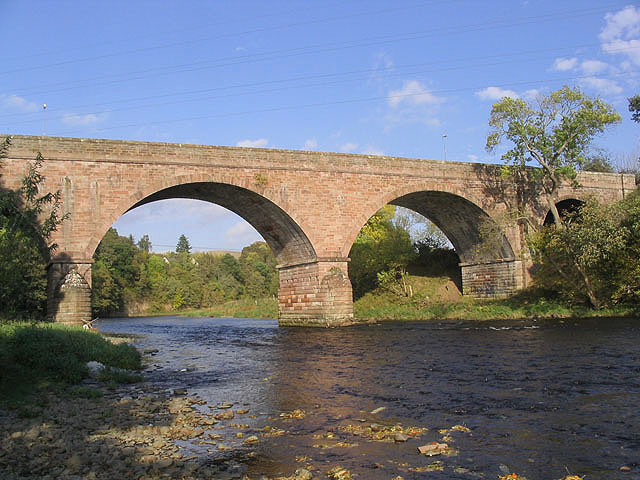
English: Redbridge Viaduct at Galafoot. This five-arched sandstone structure spans the River Tweed at Galafoot on the route of the former Waverley Railway Line. The bridge has category B listed building status and is described by Historic Scotland as a well preserved and notable example of a railway viaduct of the mid 19th century. The Waverley Line was closed in 1969 and the bridge is used for pedestrian and cycle traffic, but could be used as a railway bridge again if the proposed partial reinstatement of the Waverley Route to Tweedbank goes ahead. For a view along the bridge see 207456. |
| Date | |
| Source | From geograph.org.uk |
| Author | Walter Baxter |
| Attribution (required by the license) | Walter Baxter / Redbridge Viaduct at Galafoot / |
| Camera location | | View this and other nearby images on: OpenStreetMap |
|---|
_heading:22.00&language=en)
| Object location | | View this and other nearby images on: OpenStreetMap |
|---|
_heading:22.00&language=en)
Licensing
edit

|
This image was taken from the Geograph project collection. See this photograph's page on the Geograph website for the photographer's contact details. The copyright on this image is owned by Walter Baxter and is licensed for reuse under the Creative Commons Attribution-ShareAlike 2.0 license.
|
This file is licensed under the Creative Commons Attribution-Share Alike 2.0 Generic license.
Attribution: Walter Baxter
- You are free:
- to share – to copy, distribute and transmit the work
- to remix – to adapt the work
- Under the following conditions:
- attribution – You must give appropriate credit, provide a link to the license, and indicate if changes were made. You may do so in any reasonable manner, but not in any way that suggests the licensor endorses you or your use.
- share alike – If you remix, transform, or build upon the material, you must distribute your contributions under the same or compatible license as the original.
File history
Click on a date/time to view the file as it appeared at that time.
| Date/Time | Thumbnail | Dimensions | User | Comment | |
|---|---|---|---|---|---|
| current | 20:04, 6 February 2011 | | 640 × 480 (117 KB) | GeographBot (talk | contribs) | == {{int:filedesc}} == {{Information |description={{en|1=Redbridge Viaduct at Galafoot This five-arched sandstone structure spans the River Tweed at Galafoot on the route of the former Waverley Railway Line. The bridge has category B listed building statu |
You cannot overwrite this file.
File usage on Commons
The following page uses this file:
File usage on other wikis
The following other wikis use this file:
- Usage on de.wikipedia.org
- Usage on en.wikipedia.org
- Usage on www.wikidata.org