File:Regions of NZ Numbered.svg

Size of this PNG preview of this SVG file: 290 × 415 pixels. Other resolutions: 168 × 240 pixels | 335 × 480 pixels | 537 × 768 pixels | 715 × 1,024 pixels | 1,431 × 2,048 pixels.
Original file (SVG file, nominally 290 × 415 pixels, file size: 283 KB)
Captions
Captions
Add a one-line explanation of what this file represents
Summary edit
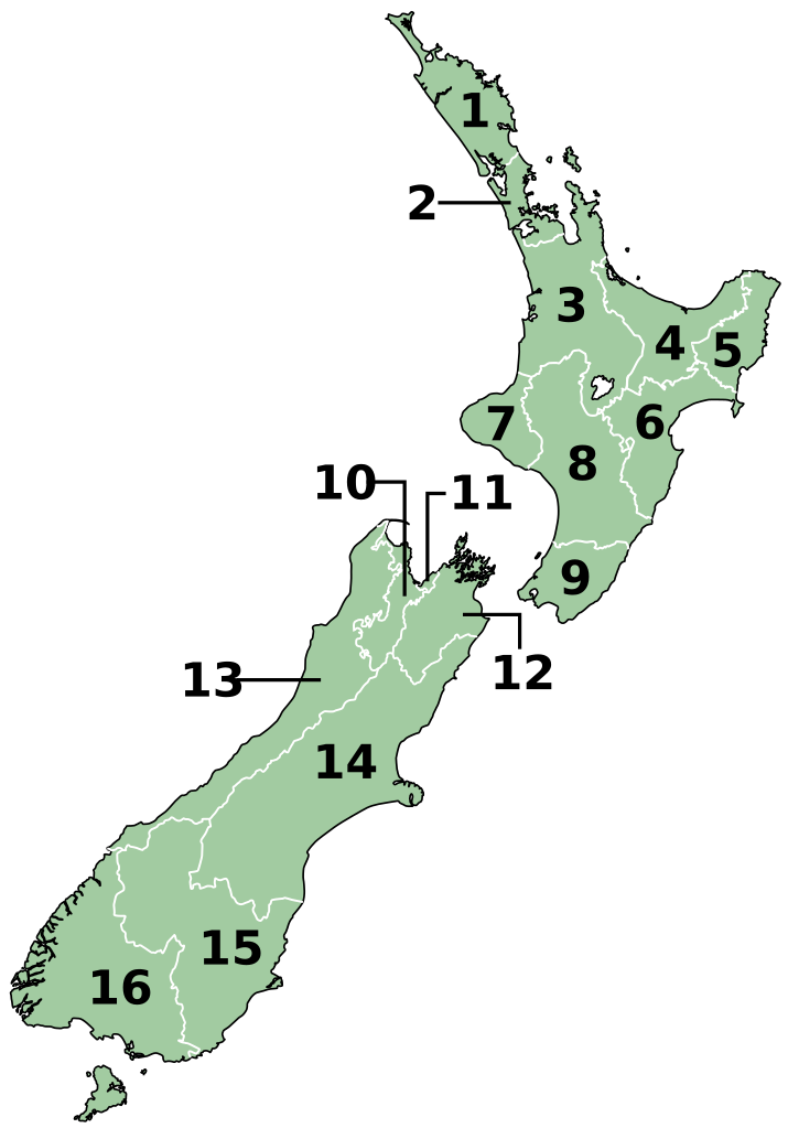
| Description | vector map of local government regions of New Zealand. Based on Image:NZ_Regions.svg by Ozhiker |
| Date | |
| Source |
Own work This W3C-unspecified vector image was created with Inkscape . |
| Author | Benchill |
1. Northland Region
2. Auckland Region
3. Waikato Region
4. Bay of Plenty Region
5. Gisborne Region
6. Hawke's Bay Region
7. Taranaki Region
8. Manawatu-Wanganui Region
9. Wellington Region
10. Tasman Region
11. Nelson Region
12. Marlborough Region
13. West Coast Region
14. Canterbury Region
15. Otago Region
16. Southland Region
Licensing edit
I, the copyright holder of this work, hereby publish it under the following licenses:

|
Permission is granted to copy, distribute and/or modify this document under the terms of the GNU Free Documentation License, Version 1.2 or any later version published by the Free Software Foundation; with no Invariant Sections, no Front-Cover Texts, and no Back-Cover Texts. A copy of the license is included in the section entitled GNU Free Documentation License. |
| This file is licensed under the Creative Commons Attribution-Share Alike 3.0 Unported license. | ||
| ||
| This licensing tag was added to this file as part of the GFDL licensing update. |
This file is licensed under the Creative Commons Attribution-Share Alike 2.5 Generic license.
- You are free:
- to share – to copy, distribute and transmit the work
- to remix – to adapt the work
- Under the following conditions:
- attribution – You must give appropriate credit, provide a link to the license, and indicate if changes were made. You may do so in any reasonable manner, but not in any way that suggests the licensor endorses you or your use.
- share alike – If you remix, transform, or build upon the material, you must distribute your contributions under the same or compatible license as the original.
You may select the license of your choice.
File history
Click on a date/time to view the file as it appeared at that time.
| Date/Time | Thumbnail | Dimensions | User | Comment | |
|---|---|---|---|---|---|
| current | 12:48, 15 June 2022 | | 290 × 415 (283 KB) | Pacha Tchernof (talk | contribs) | Fixed a border of Waikato Region near the lake as it was requested in PNG-version of the file (Media for cleanup) |
| 11:50, 25 September 2007 |  | 290 × 415 (282 KB) | Benchill (talk | contribs) | {{Information |Description= vector map of local government regions of New Zealand. Based on Image:NZ_Regions.svg by Ozhiker |Source= self-made using Inkscape |Date= 2007-09-25 |Author= Benchill }} == Licensing == { |
You cannot overwrite this file.
File usage on Commons
The following 2 pages use this file:
File usage on other wikis
The following other wikis use this file:
- Usage on an.wikipedia.org
- Usage on ar.wikipedia.org
- Usage on ast.wikipedia.org
- Usage on ban.wikipedia.org
- Usage on bg.wikipedia.org
- Usage on ca.wikipedia.org
- Usage on ckb.wikipedia.org
- Usage on cs.wikipedia.org
- Usage on cy.wikipedia.org
- Usage on en.wikipedia.org
- Usage on eo.wikipedia.org
- Usage on es.wikipedia.org
- Usage on fi.wikipedia.org
- Usage on fo.wikipedia.org
- Usage on frr.wikipedia.org
- Usage on fr.wikipedia.org
- Usage on gl.wikipedia.org
- Usage on ha.wikipedia.org
- Usage on hr.wikipedia.org
- Usage on hu.wikipedia.org
- Usage on id.wikipedia.org
- Usage on it.wikipedia.org
- Usage on ja.wikipedia.org
- Usage on ka.wikipedia.org
- Usage on mi.wikipedia.org
- Usage on mk.wikipedia.org
- Usage on ms.wikipedia.org
- Usage on nn.wikipedia.org
View more global usage of this file.