File:Representación cartográfica de la isla Montague, Baja California.jpg

Size of this preview: 800 × 555 pixels. Other resolutions: 320 × 222 pixels | 640 × 444 pixels | 1,024 × 711 pixels | 1,212 × 841 pixels.
Original file (1,212 × 841 pixels, file size: 61 KB, MIME type: image/jpeg)
Captions
Captions
Add a one-line explanation of what this file represents
Summary
edit
| Description |
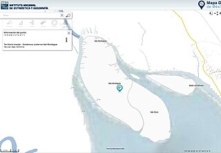
Español: Representación cartográfica de la isla Montague extraída del mapa digital de México versión 6.3 editado por el INEGI. |
| Date | |
| Source | INEGI |
| Author | INEGI |
Licensing
edit
This file is in the public domain because El uso de la presente imagen e información está sancionada por los "términos de libre uso de la información del INEGI"
|
File history
Click on a date/time to view the file as it appeared at that time.
| Date/Time | Thumbnail | Dimensions | User | Comment | |
|---|---|---|---|---|---|
| current | 18:42, 2 June 2017 | | 1,212 × 841 (61 KB) | Verdelunar (talk | contribs) | User created page with UploadWizard |
You cannot overwrite this file.
File usage on Commons
The following page uses this file:
- File:Montague.jpg (file redirect)
File usage on other wikis
The following other wikis use this file:
- Usage on es.wikipedia.org