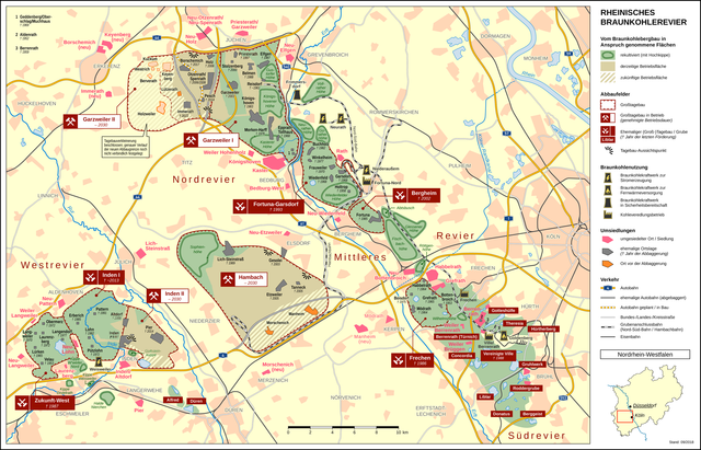
File:Rheinisches Braunkohlerevier DE.png

Size of this preview: 800 × 513 pixels. Other resolutions: 320 × 205 pixels | 640 × 411 pixels | 1,024 × 657 pixels | 1,280 × 821 pixels | 2,560 × 1,643 pixels | 3,350 × 2,150 pixels.
Original file (3,350 × 2,150 pixels, file size: 3.2 MB, MIME type: image/png)
Captions
Captions
Add a one-line explanation of what this file represents
Summary edit
| Description | ||||
| Date | September 2018 | |||
| Source |
Own work
|
|||
| Author | Thoroe | |||
| Permission (Reusing this file) |
|
|||
| Other versions |
|

|
This economic map image could be re-created using vector graphics as an SVG file. This has several advantages; see Commons:Media for cleanup for more information. If an SVG form of this image is available, please upload it and afterwards replace this template with
{{vector version available|new image name}}.
It is recommended to name the SVG file “Rheinisches Braunkohlerevier DE.svg”—then the template Vector version available (or Vva) does not need the new image name parameter. |

|
This map has been made or improved in the German Kartenwerkstatt (Map Lab). You can propose maps to improve as well.
|
Licensing edit
This file is licensed under the Creative Commons Attribution-Share Alike 2.0 Generic license.
Attribution: Thomas Römer/OpenStreetMap data
- You are free:
- to share – to copy, distribute and transmit the work
- to remix – to adapt the work
- Under the following conditions:
- attribution – You must give appropriate credit, provide a link to the license, and indicate if changes were made. You may do so in any reasonable manner, but not in any way that suggests the licensor endorses you or your use.
- share alike – If you remix, transform, or build upon the material, you must distribute your contributions under the same or compatible license as the original.
File history
Click on a date/time to view the file as it appeared at that time.
| Date/Time | Thumbnail | Dimensions | User | Comment | |
|---|---|---|---|---|---|
| current | 09:29, 15 January 2023 | | 3,350 × 2,150 (3.2 MB) | RurJülicher (talk | contribs) | Veränderung des Abbaugebiets Garzweiler |
| 10:02, 18 September 2018 |  | 3,350 × 2,150 (2.54 MB) | Thoroe (talk | contribs) | Darstellung der geplanten Verkleinerung um Holzweiler geändert | |
| 14:12, 6 September 2018 |  | 3,350 × 2,150 (2.53 MB) | Thoroe (talk | contribs) | Teil der A61 gesperrt und zum Abriss freigegeben | |
| 09:24, 12 July 2018 |  | 3,350 × 2,150 (2.78 MB) | Thoroe (talk | contribs) | Complete revision | |
| 11:40, 13 April 2015 |  | 1,962 × 1,496 (1.43 MB) | Thoroe (talk | contribs) | verlorengegangene Halden-Umrandungen wiederhergestellt | |
| 11:07, 26 September 2014 |  | 1,961 × 1,495 (1.36 MB) | Thoroe (talk | contribs) | auch Inden-Pier ist wohl schon nicht mehr existent | |
| 16:18, 25 September 2014 |  | 1,961 × 1,495 (1.36 MB) | Thoroe (talk | contribs) | Verlegung A4, B477 und Hambachbahn abgeschlossen (die B477 habe ich an der neuen Anschlussstelle Elsdorf schon mal als fertig eingezeichnet), Pesch abgebaggert | |
| 22:35, 15 June 2013 |  | 1,962 × 1,496 (1.45 MB) | Thoroe (talk | contribs) | + Morschenich neu | |
| 18:06, 31 January 2013 |  | 1,962 × 1,496 (1.49 MB) | Thoroe (talk | contribs) | Noch ein paar Korrekturen und Ergänzungen | |
| 21:45, 30 January 2013 |  | 1,962 × 1,496 (1.44 MB) | Thoroe (talk | contribs) | Karte umgebaut und erweitert: jetzt mit ehemaligen und umgesiedelten Ortschaften |
You cannot overwrite this file.
File usage on Commons
The following 9 pages use this file:
- Aachener Revier
- Top 200 images that should use vector graphics
- User:Chumwa/OgreBot/Public transport information/2023 January 11-20
- User:Chumwa/OgreBot/Transport Maps/2023 January 11-20
- Commons:Quality images candidates/Archives February 22 2014
- Category:Hambachbahn
- Category:Open-pit lignite mines in the Rhenish area
- Category:Rhenish lignite mining area
- Category:Tagebau Hambach
File usage on other wikis
The following other wikis use this file:
- Usage on ar.wikipedia.org
- Usage on arz.wikipedia.org
- Usage on ca.wikipedia.org
- Usage on cs.wikipedia.org
- Usage on da.wikipedia.org
- Usage on de.wikipedia.org
- Garsdorf (Bedburg)
- Garzweiler
- Laurenzberg
- Kraftwerk Goldenberg
- Nord-Süd-Bahn (Garzweiler)
- Hambachbahn
- Tagebau Hambach
- Tagebau Inden
- Tagebau Garzweiler
- Kraftwerk Weisweiler
- Kraftwerk Neurath
- Braunkohlebergbau
- Sophienhöhe (Jülich)
- Königshoven
- Langweiler 8
- Lürken
- Inden/Altdorf
- Kraftwerk Frimmersdorf
- Liste abgebaggerter Ortschaften
- Neu-Lohn
- Erberich
- Pützlohn
- Lohn (Eschweiler)
- Frauweiler
- Wiedenfeld
- Wiedenfelder Höhe
- Burg Holtrop
- Langendorf (Eschweiler)
- Weiler Langweiler
- Altdorf (Inden)
- Alt-Otzenrath
- Glessener Höhe
- Manheim
- Fortuna (Bergheim)
- Alt-Spenrath
- Kohleveredlungsbetrieb Fortuna-Nord
- Tagebau Bergheim
- Kohleveredlungsbetrieb Frechen
- Rheinisches Braunkohlerevier
- Alt-Holz
- Pier (Inden)
- Langweiler (Aldenhoven)
- Pattern (Aldenhoven)
- Pier (Langerwehe)
- Velau (Hehlrath)
View more global usage of this file.