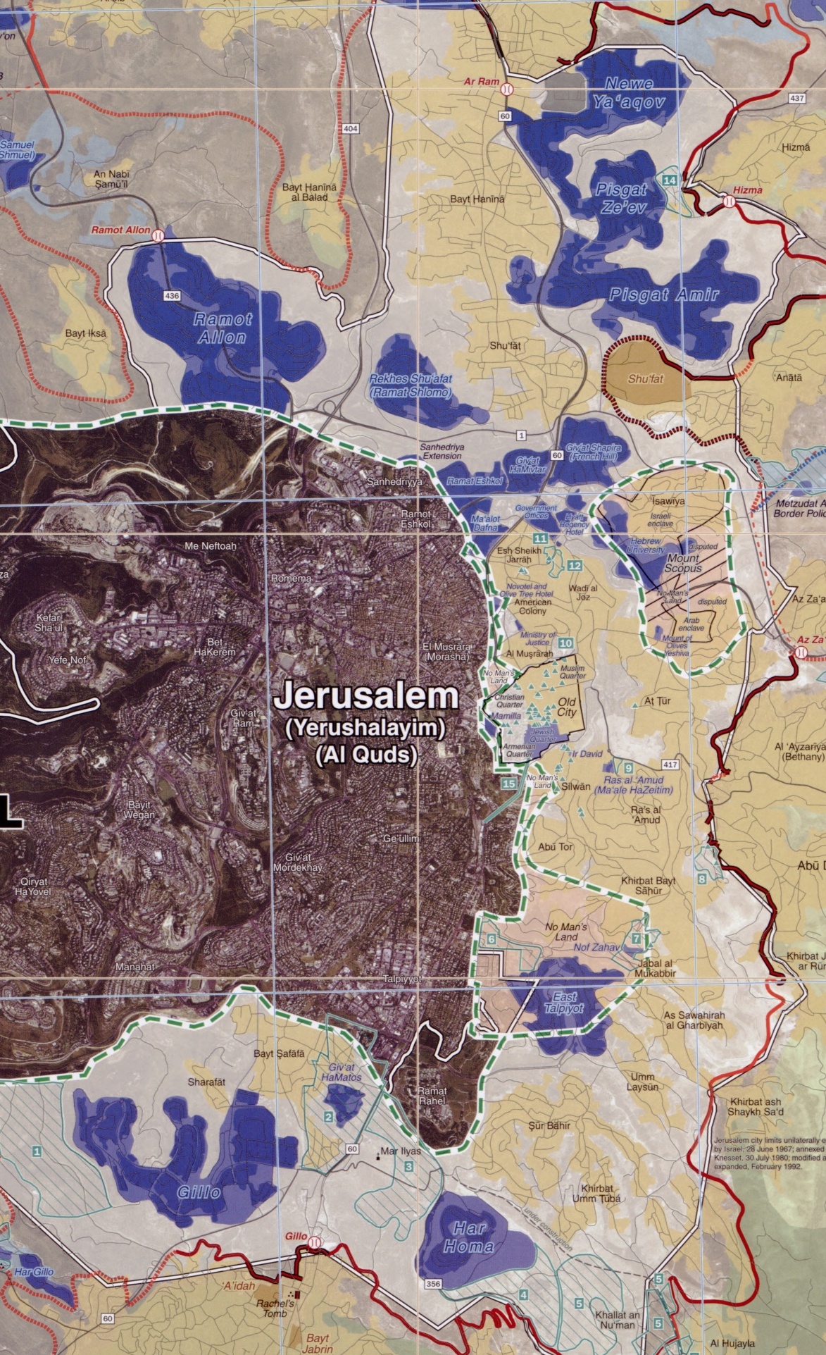
File:Ring Neighborhoods Settlements in Greater Jerusalem May 2006 CIA remote-sensing map 3500px (cropped).jpg
Size of this preview: 365 × 598 pixels. Other resolutions: 146 × 240 pixels | 293 × 480 pixels | 468 × 768 pixels | 1,173 × 1,923 pixels.
Original file (1,173 × 1,923 pixels, file size: 1.06 MB, MIME type: image/jpeg)
Captions
Captions
Add a one-line explanation of what this file represents
Note: This is a smaller 3500-pixel-wide version of the original map. The original map on the Commons is 8,264 × 10,696 pixels and has a huge file size of 53.3 MB. This 3500-pixel-wide version of the map is 5.54 MB. A warning on the page for the larger image: {{LargeImage}}
| Description |
English: Greater Jerusalem, May 2006. United States. Central Intelligence Agency. CREATED/PUBLISHED [Washington, D.C.] : Central Intelligence Agency, [2006] NOTES Shows settlements, refugee camps, fences, walls, etc. "Imagery base: SPOT 5 multispectral imagery acquired July 2004." Includes chart describing plans for new settlements. "803197AI (G00307) 5-06." Scale 1:40,000 ; universal transverse Mercator proj. (E 35006'--E 35021'/N 31054'--N 310390). MEDIUM 1 remote-sensing map : col. ; 87 x 67 cm. CALL NUMBER G7504.J4G4 2006 .U5 REPOSITORY Library of Congress Geography and Map Division Washington, D.C. 20540-4650 USA DIGITAL ID g7504j ct001915 http://hdl.loc.gov/loc.gmd/g7504j.ct001915 Note:Image converted from jp2 -> jpg |
| Date | (UTC) |
| Source | This is a 3500-pixel-wide version of the above-linked original map that is 8,264 × 10,696 pixels, with a file size of 53.3 MB. This 3500-pixel-wide version is 5.54 MB. |
| Author |
|
| Other versions |

| This work is from the Library of Congress. According to the library, there are no known copyright restrictions on the use of this work. |  |
Original upload log edit
.jpg&action=edit§ion=1)
This image is a derivative work of the following images:
- File:Greater_Jerusalem_May_2006_CIA_remote-sensing_map_.jpg licensed with PD-USGov
- 2010-04-24T11:10:11Z Sean.hoyland 8264x10696 (55888328 Bytes) {{Information |Description={{en|1=Greater Jerusalem, May 2006. United States. Central Intelligence Agency. CREATED/PUBLISHED [Washington, D.C.] : Central Intelligence Agency, [2006] NOTES Shows settlements, refugee camps, fe
Uploaded with derivativeFX
File history
Click on a date/time to view the file as it appeared at that time.
| Date/Time | Thumbnail | Dimensions | User | Comment | |
|---|---|---|---|---|---|
| current | 21:16, 27 January 2023 | | 1,173 × 1,923 (1.06 MB) | Onceinawhile (talk | contribs) | File:Greater Jerusalem May 2006 CIA remote-sensing map 3500px.jpg cropped 66 % horizontally, 58 % vertically using CropTool with precise mode. |
You cannot overwrite this file.
File usage on Commons
The following 2 pages use this file:
File usage on other wikis
The following other wikis use this file:
- Usage on en.wikipedia.org
.jpg&oldid=749916179)