File:Riparian vegetation.jpg
Riparian_vegetation.jpg (609 × 356 pixels, file size: 305 KB, MIME type: image/jpeg)
File information
Structured data
Captions
Summary edit
DescriptionRiparian vegetation.jpg |
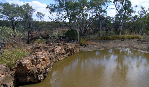
English: Riparian habitats, Yapunyah Waterhole. |
Date | |
Source | Desert Channels Qld |
Author | Helen Cross |
Licensing edit
This file is licensed under the Creative Commons Attribution-Share Alike 3.0 Unported license.
- You are free:
- to share – to copy, distribute and transmit the work
- to remix – to adapt the work
- Under the following conditions:
- attribution – You must give appropriate credit, provide a link to the license, and indicate if changes were made. You may do so in any reasonable manner, but not in any way that suggests the licensor endorses you or your use.
- share alike – If you remix, transform, or build upon the material, you must distribute your contributions under the same or compatible license as the original.
File history
Click on a date/time to view the file as it appeared at that time.
Date/Time | Thumbnail | Dimensions | User | Comment | |
---|---|---|---|---|---|
current | 05:16, 13 March 2013 | 609 × 356 (305 KB) | Desertd (talk | contribs) | User created page with UploadWizard |
You cannot overwrite this file.
File usage on Commons
There are no pages that use this file.
File usage on other wikis
The following other wikis use this file:
- Usage on en.wikipedia.org
Metadata
This file contains additional information such as Exif metadata which may have been added by the digital camera, scanner, or software program used to create or digitize it. If the file has been modified from its original state, some details such as the timestamp may not fully reflect those of the original file. The timestamp is only as accurate as the clock in the camera, and it may be completely wrong.
Camera manufacturer | RICOH |
---|---|
Camera model | Caplio 500SE |
Copyright holder |
|
Exposure time | 1/470 sec (0.0021276595744681) |
F-number | f/4.7 |
ISO speed rating | 64 |
Date and time of data generation | 14:06, 6 October 2011 |
Lens focal length | 5.8 mm |
Latitude | 0° 0′ 0″ N |
Longitude | 0° 0′ 0″ E |
Altitude | 0 meters above sea level |
Orientation | Normal |
Horizontal resolution | 72 dpi |
Vertical resolution | 72 dpi |
Software used | Adobe Photoshop Elements 10.0 Macintosh |
File change date and time | 15:38, 7 October 2012 |
Y and C positioning | Co-sited |
Exposure Program | Normal program |
Exif version | 2.21 |
Date and time of digitizing | 14:06, 6 October 2011 |
Meaning of each component |
|
Image compression mode | 1.6 |
APEX aperture | 4.4 |
APEX brightness | 6.6 |
APEX exposure bias | 0 |
Maximum land aperture | 2.5 APEX (f/2.38) |
Metering mode | Pattern |
Light source | Unknown |
Flash | Flash did not fire, compulsory flash suppression |
Supported Flashpix version | 1 |
Color space | sRGB |
Exposure mode | Auto exposure |
White balance | Auto white balance |
Scene capture type | Standard |
Sharpness | Normal |
GPS time (atomic clock) | 00:00 |
Receiver status | Measurement interoperability |
Measurement mode | 2-dimensional measurement |
Measurement precision | Excellent (0) |
Speed unit | Knots |
Reference for direction of movement | True direction |
Direction of movement | 0 |
Reference for direction of image | Magnetic direction |
Direction of image | 212.3 |
Geodetic survey data used | WGS-84 |
Reference for bearing of destination | True direction |
Reference for distance to destination | Kilometers |
GPS date | 6 October 2011 |
GPS differential correction | 0 |
GPS tag version | 2.2.0.0 |
Supported Flashpix version | 1 |
Image width | 609 px |
Image height | 356 px |
Satellites used for measurement | |
Date metadata was last modified | 01:38, 8 October 2012 |
Unique ID of original document | xmp.did:941999A908206811822AEB6B9AF1B9FE |