File:Roadcut dike in Walsenburg, Colorado.JPG

Size of this preview: 800 × 547 pixels. Other resolutions: 320 × 219 pixels | 640 × 438 pixels | 1,024 × 700 pixels | 1,280 × 875 pixels | 2,560 × 1,750 pixels | 5,390 × 3,685 pixels.
Original file (5,390 × 3,685 pixels, file size: 15.07 MB, MIME type: image/jpeg)
Captions
Captions
Add a one-line explanation of what this file represents
Summary edit
| Description |
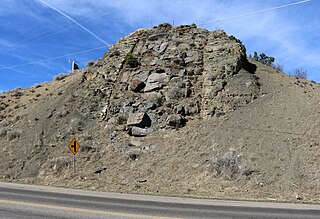
English: A cross-section view of a magmatic dike along Walsen Avenue in Walsenburg, Colorado. The buried dike runs along the north side of town and is called "The Hogback" by locals. The roadcut view shows the dike in the center with baked sedimentary strata on either side. |
| Date | |
| Source | Own work |
| Author | Jeffrey Beall |
| Object location | | View this and other nearby images on: OpenStreetMap |
|---|
Licensing edit
I, the copyright holder of this work, hereby publish it under the following license:
This file is licensed under the Creative Commons Attribution 4.0 International license.
- You are free:
- to share – to copy, distribute and transmit the work
- to remix – to adapt the work
- Under the following conditions:
- attribution – You must give appropriate credit, provide a link to the license, and indicate if changes were made. You may do so in any reasonable manner, but not in any way that suggests the licensor endorses you or your use.
File history
Click on a date/time to view the file as it appeared at that time.
| Date/Time | Thumbnail | Dimensions | User | Comment | |
|---|---|---|---|---|---|
| current | 16:06, 2 April 2018 | | 5,390 × 3,685 (15.07 MB) | Jeffrey Beall (talk | contribs) | {{Information |description ={{en|1=A cross-section view of a magmatic dike along Walsen Avenue in Walsenburg, Colorado. The buried dike runs along the north side of town and is called "The Hogback" by locals. The roadcut view shows the dike in the center with bake sedimentary strata on either side.}} |source ={{own}} |author =Jeffrey Beall |date =2018-03-30 }} {{Object location|37|38|9|N|104|47|23.27|W}} Category:Volcanic dikes in Colorado [... |
You cannot overwrite this file.
File usage on Commons
There are no pages that use this file.