File:Roman Empire full - Referenced.jpg
Size of this preview: 749 × 599 pixels. Other resolutions: 300 × 240 pixels | 600 × 480 pixels | 960 × 768 pixels | 1,116 × 893 pixels.
Original file (1,116 × 893 pixels, file size: 303 KB, MIME type: image/jpeg)
Captions
Captions
Add a one-line explanation of what this file represents
Summary edit
| Description |
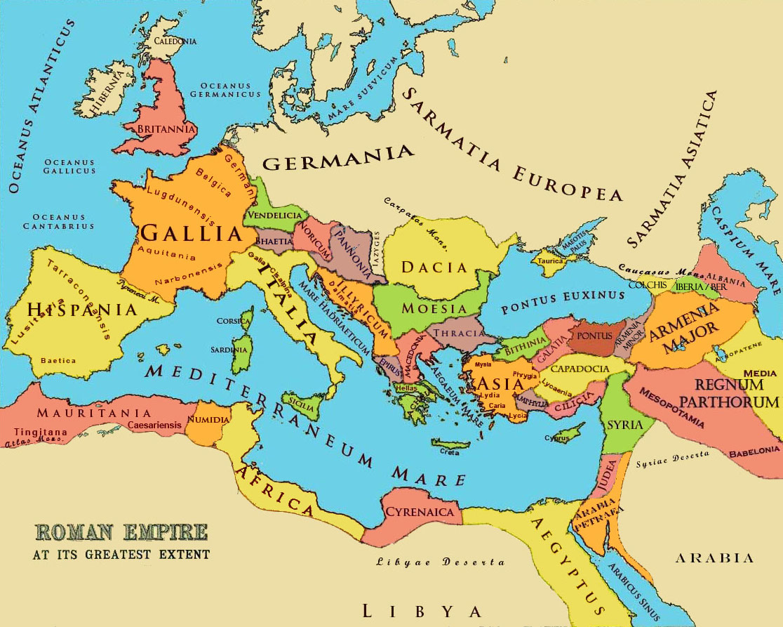
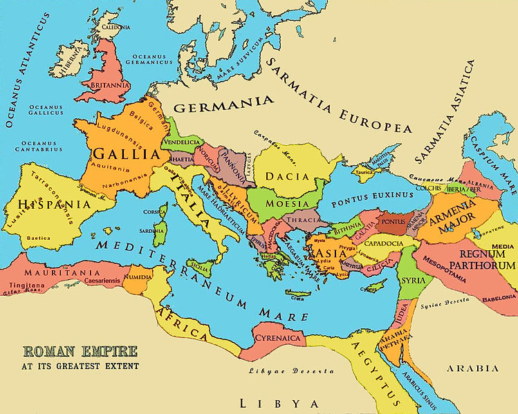
English: A referenced map of the Roman Empire at its greatest extent in the 2-3 cc. The borders of states and markings are referenced to a published historical atlas in public domain. |
| Date | 21 May 2010 (original upload date); 26 June 2010 (last version) |
| Source |
|
| Author |
Aregakn at en.wikipedia. Later versions were uploaded by Beao at en.wikipedia. |

Licensing edit
Aregakn at en.wikipedia, the copyright holder of this work, hereby publishes it under the following licenses:
This file is licensed under the Creative Commons Attribution-Share Alike 3.0 Unported license.
Attribution: Aregakn at en.wikipedia
- You are free:
- to share – to copy, distribute and transmit the work
- to remix – to adapt the work
- Under the following conditions:
- attribution – You must give appropriate credit, provide a link to the license, and indicate if changes were made. You may do so in any reasonable manner, but not in any way that suggests the licensor endorses you or your use.
- share alike – If you remix, transform, or build upon the material, you must distribute your contributions under the same or compatible license as the original.

|
Permission is granted to copy, distribute and/or modify this document under the terms of the GNU Free Documentation License, Version 1.2 or any later version published by the Free Software Foundation; with no Invariant Sections, no Front-Cover Texts, and no Back-Cover Texts. A copy of the license is included in the section entitled GNU Free Documentation License. |
You may select the license of your choice.
Original upload log edit
The original description page was here. All following user names refer to en.wikipedia.
- 2010-06-26 13:26 Beao 1116×893× (309793 bytes)
- 2010-05-29 06:05 Aregakn 1119×897× (258809 bytes) less colorful
- 2010-05-21 09:36 Aregakn 1119×897× (204488 bytes) A referenced map of the Roman Empire at it's greatest extent in the 2-3 cc. The borders of states and markings are referenced to a published historical atlas in public domain. Ref: [http://people.ucalgary.ca/~vandersp/Courses/maps/basicmap.html]
File history
Click on a date/time to view the file as it appeared at that time.
| Date/Time | Thumbnail | Dimensions | User | Comment | |
|---|---|---|---|---|---|
| current | 01:18, 3 August 2011 | | 1,116 × 893 (303 KB) | OgreBot (talk | contribs) | (BOT): Reverting to most recent version; originally uploaded at en.wikipedia on 2010-06-26 13:26:19 by Beao |
| 01:18, 3 August 2011 |  | 1,119 × 897 (253 KB) | OgreBot (talk | contribs) | (BOT): Uploading old version of file from en.wikipedia; originally uploaded on 2010-05-29 06:05:55 by Aregakn | |
| 01:18, 3 August 2011 |  | 1,119 × 897 (200 KB) | OgreBot (talk | contribs) | (BOT): Uploading old version of file from en.wikipedia; originally uploaded on 2010-05-21 09:36:27 by Aregakn | |
| 21:51, 7 June 2011 |  | 1,116 × 893 (303 KB) | Davius (talk | contribs) |
You cannot overwrite this file.
File usage on Commons
There are no pages that use this file.
File usage on other wikis
The following other wikis use this file:
- Usage on ar.wikipedia.org
- Usage on bg.wikipedia.org
- Usage on ca.wikipedia.org
- Usage on en.wikipedia.org
- Usage on es.wikipedia.org
- Usage on fr.wiktionary.org
- Usage on hy.wikipedia.org
- Usage on hyw.wikipedia.org
- Usage on it.wikipedia.org
- Usage on it.wikibooks.org
- Usage on ms.wikipedia.org
- Usage on tr.wikipedia.org