File:Roman gold polygonal finger-ring (FindID 986782).jpg
Original file (1,379 × 825 pixels, file size: 158 KB, MIME type: image/jpeg)
Captions
Captions
Summary edit
.jpg&action=edit§ion=1)
| Roman gold polygonal finger-ring | |||
|---|---|---|---|
| Photographer |
The Portable Antiquities Scheme, Matthew Fittock, 2020-01-08 11:35:50 |
||
| Title |
Roman gold polygonal finger-ring |
||
| Description |
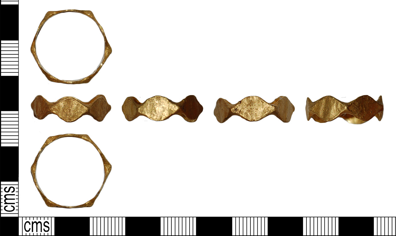
English: Description: A complete cast Roman gold polygonal finger-ring of Henig's type IX, dating to the period AD 200-300. The ring is formed of a circular hoop comprising seven irregular lozenge-shaped facets of similar dimensions, all plain and undecorated. The surface of this ring is roughly finished on the inside and out.
Henig, M. 1974. A Corpus of Roman Engraves Gemstones From British Sites. British Archaeological Reports, Oxford, fig. 2. IX. |
||
| Depicted place | (County of findspot) Buckinghamshire | ||
| Date | between 200 and 300 | ||
| Accession number |
FindIdentifier: 986782 |
||
| Credit line |
|
||
| Source |
https://finds.org.uk/database/ajax/download/id/1087124 Catalog: https://finds.org.uk/database/images/image/id/1087124/recordtype/artefacts archive copy at the Wayback Machine Artefact: https://finds.org.uk/database/artefacts/record/id/986782 |
||
| Permission (Reusing this file) |
Attribution License version 2.0 (verified 18 November 2020) | ||
| Object location | | View this and other nearby images on: OpenStreetMap |
|---|
.jpg¶ms=051.737600_N_-000.862841_E_globe:Earth_class:object_type:object__&language=en)
Licensing edit
.jpg&action=edit§ion=2)
- You are free:
- to share – to copy, distribute and transmit the work
- to remix – to adapt the work
- Under the following conditions:
- attribution – You must give appropriate credit, provide a link to the license, and indicate if changes were made. You may do so in any reasonable manner, but not in any way that suggests the licensor endorses you or your use.
File history
Click on a date/time to view the file as it appeared at that time.
| Date/Time | Thumbnail | Dimensions | User | Comment | |
|---|---|---|---|---|---|
| current | 12:11, 15 November 2020 | | 1,379 × 825 (158 KB) | Fæ (talk | contribs) | Portable Antiquities Scheme, BH, FindID: 986782-1087124, roman, page 847, batch count 3685 |
You cannot overwrite this file.
File usage on Commons
The following page uses this file:
.jpg)
File usage on other wikis
The following other wikis use this file:
- Usage on en.wikipedia.org
.jpg&oldid=687257104)