File:Route map of S-train ja.svg

Size of this PNG preview of this SVG file: 800 × 600 pixels. Other resolutions: 320 × 240 pixels | 640 × 480 pixels | 1,024 × 768 pixels | 1,280 × 960 pixels | 2,560 × 1,920 pixels.
Original file (SVG file, nominally 1,024 × 768 pixels, file size: 2.57 MB)
Captions
Captions
Add a one-line explanation of what this file represents
Summary edit
| Description |
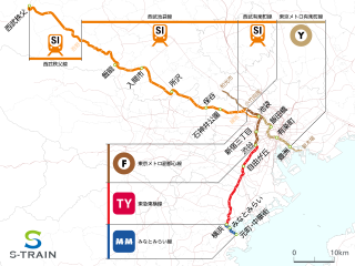
English: Line map of S-Train, Tokyo
日本語: S-Trainの路線図 |
|||
| Date | ||||
| Source | 国土数値情報 | |||
| Author | Syohei Arai (talk) | |||
| Permission (Reusing this file) |
|
|||
| Other versions | file:Route_map_of_S-train_en.svg(Station name in English) |
This vector image was created with Adobe Illustrator.
| Annotations | This image is annotated: View the annotations at Commons |
File history
Click on a date/time to view the file as it appeared at that time.
| Date/Time | Thumbnail | Dimensions | User | Comment | |
|---|---|---|---|---|---|
| current | 09:35, 23 November 2018 | | 1,024 × 768 (2.57 MB) | Araisyohei (talk | contribs) | add line name |
| 14:31, 17 November 2018 |  | 1,024 × 768 (2.53 MB) | Araisyohei (talk | contribs) | {{Information |Description={{en|1=Line map of S-Train, Tokyo}} {{ja|1=S-Trainの路線図}} |Source=国土数値情報 |Author=<font color=green>Syohei Arai</font> (talk) |Date=2018-11-17 |Permission={{CC-zero}} |other_versions=File:ShonanMonorail_Linemap_en.svg(Station name in English) |Other fields = }} {{Created with Adobe Illustrator}} Category:Rail transport maps of Japan Category:Public transport maps of Japan Category:Files by Araisyohei [[C... |
You cannot overwrite this file.
File usage on Commons
The following 9 pages use this file:
- User:Chumwa/OgreBot/Potential transport maps/2018 November 11-20
- User:Chumwa/OgreBot/Potential transport maps/2018 November 21-30
- User:Chumwa/OgreBot/Public transport information/2018 November 11-20
- User:Chumwa/OgreBot/Public transport information/2018 November 21-30
- User:Chumwa/OgreBot/Transport Maps/2018 November 11-20
- User:Chumwa/OgreBot/Transport Maps/2018 November 21-30
- User:Chumwa/OgreBot/Travel and communication maps/2018 November 11-20
- User:Chumwa/OgreBot/Travel and communication maps/2018 November 21-30
- User:콩가루/일본철도/2018 November
File usage on other wikis
The following other wikis use this file: