File:Royal Military Canal - parapet path - geograph.org.uk - 727635.jpg
No higher resolution available.
Royal_Military_Canal_-_parapet_path_-_geograph.org.uk_-_727635.jpg (640 × 457 pixels, file size: 125 KB, MIME type: image/jpeg)
Captions
Captions
Add a one-line explanation of what this file represents
Summary edit
| Description |
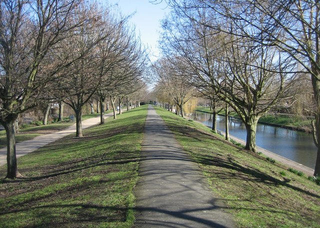
English: Royal Military Canal - parapet path The canal was built to defend England when Napoleon started to mass an army of some 130,000 troops and 2,000 boats on the French coast near Boulogne. It was started on 30 October 1804 but only finished in April 1809, well after Napoleons plans for invasion had suffered a major setback following his navys defeat at the Battle of Trafalgar in 1805.
The journalist William Cobbett, who toured the country on his Rural Rides during the 1820s, was typical of the critics of the canal: Here is a canal made for the length of thirty miles to keep out the French; for those armies who had so often crossed the Rhine and the Danube were to be kept back by a canal thirty feet wide at most! The view in the photo is along the north bank parapet which was built up from the excavated soil. |
| Date | |
| Source | From geograph.org.uk |
| Author | Sebastian Ballard |
| Camera location | | View this and other nearby images on: OpenStreetMap |
|---|
_heading:67.00&language=en)
| Object location | | View this and other nearby images on: OpenStreetMap |
|---|
_heading:67.00&language=en)
Licensing edit

|
This image was taken from the Geograph project collection. See this photograph's page on the Geograph website for the photographer's contact details. The copyright on this image is owned by Sebastian Ballard and is licensed for reuse under the Creative Commons Attribution-ShareAlike 2.0 license.
|
This file is licensed under the Creative Commons Attribution-Share Alike 2.0 Generic license.
Attribution: Sebastian Ballard
- You are free:
- to share – to copy, distribute and transmit the work
- to remix – to adapt the work
- Under the following conditions:
- attribution – You must give appropriate credit, provide a link to the license, and indicate if changes were made. You may do so in any reasonable manner, but not in any way that suggests the licensor endorses you or your use.
- share alike – If you remix, transform, or build upon the material, you must distribute your contributions under the same or compatible license as the original.
File history
Click on a date/time to view the file as it appeared at that time.
| Date/Time | Thumbnail | Dimensions | User | Comment | |
|---|---|---|---|---|---|
| current | 05:35, 19 February 2011 | | 640 × 457 (125 KB) | GeographBot (talk | contribs) | == {{int:filedesc}} == {{Information |description={{en|1=Royal Military Canal - parapet path The canal was built to defend England when Napoleon started to mass an army of some 130,000 troops and 2,000 boats on the French coast near Boulogne. It was start |
You cannot overwrite this file.
File usage on Commons
There are no pages that use this file.