File:Royalton (Township) NYPL1602501.tiff

Size of this JPG preview of this TIF file: 505 × 599 pixels. Other resolutions: 202 × 240 pixels | 405 × 480 pixels | 647 × 768 pixels | 863 × 1,024 pixels | 1,726 × 2,048 pixels | 5,392 × 6,396 pixels.
Original file (5,392 × 6,396 pixels, file size: 98.67 MB, MIME type: image/tiff)
Captions
Captions
Add a one-line explanation of what this file represents
Summary edit
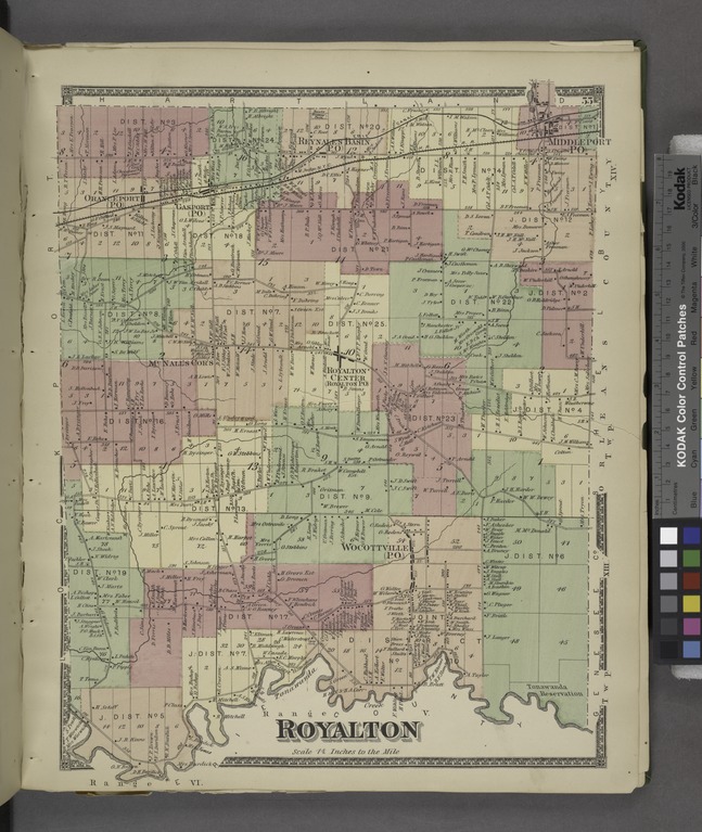
| Description | Royalton [Township]; Atlases of the United States / New York / Atlas of Niagara and Orleans counties, New York. From actual surveys and official records. Compiled and published by Beers, Upton and Co. | |||||||||||||||||||||||
| Catalogue call number | Map Div.++ (New York State) (Beers, Upton and Co., Philadelphia. Atlas of Niagara and Orleans counties, New York) | |||||||||||||||||||||||
| Item/Page/Plate | 55 | |||||||||||||||||||||||
| Date | ||||||||||||||||||||||||
| Source |
http://digitalgallery.nypl.org/nypldigital/dgkeysearchdetail.cfm?imageID=1602501
|
|||||||||||||||||||||||
| Author | D.G. Beers and Co. -- Publisher | |||||||||||||||||||||||
| Permission (Reusing this file) |
From The Lionel Pincus and Princess Firyal Map Division. http://maps.nypl.org
|
|||||||||||||||||||||||
| Source description | 113 p. 41 col. maps (1 fold., part double) 42 cm. | |||||||||||||||||||||||
| Location | Stephen A. Schwarzman Building / The Lionel Pincus and Princess Firyal Map Division | |||||||||||||||||||||||
| Digital item published | 10-29-2007; updated 3-25-2011 | |||||||||||||||||||||||
| Digital ID | 1602501 | |||||||||||||||||||||||

The making of this file was supported by Wikimedia UK.
To see other files made with the support of Wikimedia UK, please see the category Supported by Wikimedia UK.
|
File history
Click on a date/time to view the file as it appeared at that time.
| Date/Time | Thumbnail | Dimensions | User | Comment | |
|---|---|---|---|---|---|
| current | 01:09, 8 May 2014 |  | 5,392 × 6,396 (98.67 MB) | Fæ (talk | contribs) | GWToolset: Creating mediafile for Fæ. Tranche 4 -4989 restart @08:55 BST, 7 May 2014 |
You cannot overwrite this file.
File usage on Commons
There are no pages that use this file.