File:Rozhdestvenskiy (LOLA).png

Size of this preview: 600 × 600 pixels. Other resolutions: 240 × 240 pixels | 480 × 480 pixels | 1,000 × 1,000 pixels.
Original file (1,000 × 1,000 pixels, file size: 667 KB, MIME type: image/png)
File information
Structured data
Captions
Captions
Add a one-line explanation of what this file represents
Summary edit
| DescriptionRozhdestvenskiy (LOLA).png |
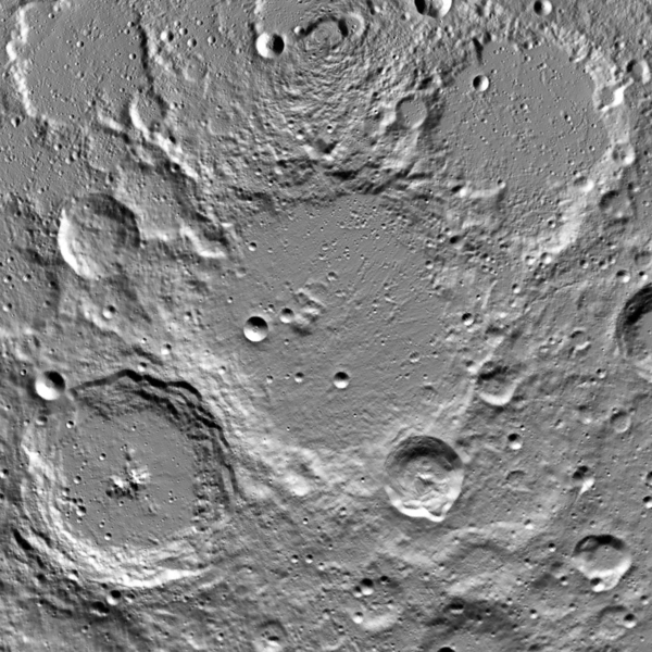
Українська: 180-кілометровий кратер Рождественський на Місяці, біля північного полюсу. Видно й кілька інших найменованих кратерів, найбільші з яких — Пласкетт (ліворуч унизу) та Ерміт (праворуч угорі). Координати центру зображення — 85°N, 202°E. Зображення побудовано за даними лазерного альтиметру Lunar Orbiter Laser Altimeter (LOLA) на космічному апараті Lunar Reconnaissance Orbiter. Ширина — 340 км, північний полюс біля верхнього краю. English: Crater Rozhdestvenskiy (diam. 180 km) on the Moon, near the North pole. Several craters around also have proper names (Plaskett at lower left, Hermite at upper right and some smaller). The image is centered at 85°N, 202°E. The image is build from data by Lunar Orbiter Laser Altimeter (LOLA) aboard the Lunar Reconnaissance Orbiter. Width of the image is 340 km; North pole is near upper margin. |
| Date | |
| Source | JMARS |
| Author | NASA (image by Lunar Reconnaissance Orbiter) |
Licensing edit
| Public domainPublic domainfalsefalse |
| This file is in the public domain in the United States because it was solely created by NASA. NASA copyright policy states that "NASA material is not protected by copyright unless noted". (See Template:PD-USGov, NASA copyright policy page or JPL Image Use Policy.) |  | |
 |
Warnings:
|
File history
Click on a date/time to view the file as it appeared at that time.
| Date/Time | Thumbnail | Dimensions | User | Comment | |
|---|---|---|---|---|---|
| current | 22:28, 4 December 2014 |  | 1,000 × 1,000 (667 KB) | Sneeuwschaap (talk | contribs) | User created page with UploadWizard |
You cannot overwrite this file.
File usage on Commons
There are no pages that use this file.
File usage on other wikis
The following other wikis use this file:
- Usage on ca.wikipedia.org
- Usage on en.wikipedia.org
- Usage on es.wikipedia.org
- Usage on zh.wikipedia.org
Metadata
This file contains additional information such as Exif metadata which may have been added by the digital camera, scanner, or software program used to create or digitize it. If the file has been modified from its original state, some details such as the timestamp may not fully reflect those of the original file. The timestamp is only as accurate as the clock in the camera, and it may be completely wrong.
| Horizontal resolution | 28.34 dpc |
|---|---|
| Vertical resolution | 28.34 dpc |